COPYRIGHT 2004 – 2026
The contents of this website are Copyright to David Billings. No portion of this website story may be used without permission. All Rights to the content of this story based on the Earhart Lockheed Electra 10E aircraft being on New Britain Island are Copyright to David Billings and the story is the Intellectual Property of David Billings.
Introductory (Home) Page References and Notes
Text:
David Billings research and analysis, and interviews with Australian Second World War patrol members. Earhart flight and radio references are public record.
Images:
Top Banner: Altered photograph of river near Wide Bay,ENB,PNG, Project photo archives, 2015.
Bottom Banner: Photo of Earhart Electra in flight (enhanced and cropped), Miami, Florida, 1 June 1937, RG-26-XC-872144, National Archives and Records Administration. 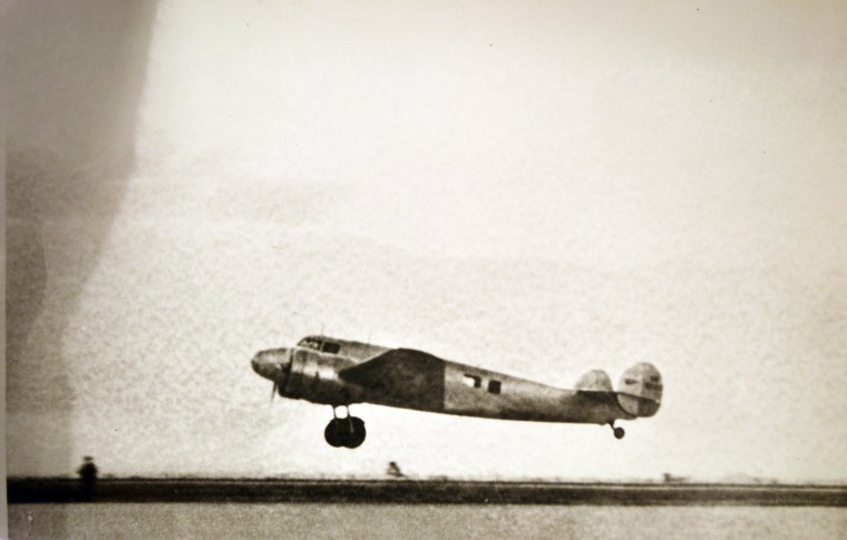
Illustrations:
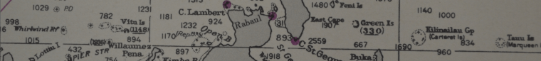
Central and Southwest Pacific Area map: Possible air route and postulated return route (D Billings), map section from Field Monograph of Marquesas and Southeast Pacific Islands, CNO, Department of Naval Intelligence, June 23, 1942. RG-495, National Archives and Records Administration.
Presentation slides (2): D Billings, see Part 4 for content references.
Part 1 Notes and References
Text:
David Billings research and analysis. Earhart flight and aircraft references are public record and Purdue University archives/library. Earhart and Noonan personal information public record and Purdue University archives/library. “Amelia – a Life of the Aviation Legend” by Donald M. Goldstein and Katherine V. Dillon, 1997.
Images:
Top Banner: Photograph (cropped) of Earhart Electra at Darwin, Australia, late June 1937. RG-26-XC-402950, National Archives and Records Administration. 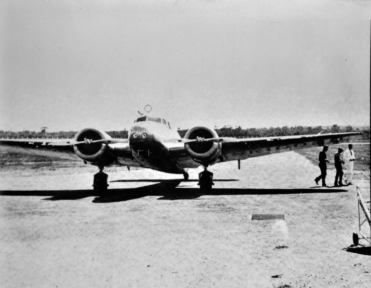
Earhart photograph from USA National Portrait Gallery, online.
Noonan photograph from National Archives of Australia, online.
Luke Field, Ford Island, Pearl Harbor, Oahu, Hawaii aerial photograph, 23 June 1936. RG-80-G-458679, National Archives and Records Administration. Close-up below. 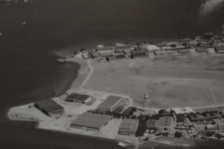
(Unused reference) Honolulu Airport, Oahu, Hawaii, aerial photograph, 5 April 1932. RG-80-G-409996, National Archives and Records Administration. 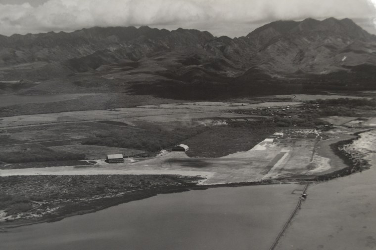
(Unused reference) Wheeler Field, Oahu, Hawaii, aerial photograph, 15 October 1930. RG-80-G-409985, National Archives and Records Administration. 
Electra Crash Photographs on Ford Island: 20 March 1937. Associated Press and RG-80-G-410136, National Archives and Records Administration.
Lae Airfield, New Guinea aerial photograph, 1937. Australian War Memorial, online.
Illustrations:
(Unused References) Lockheed Electra 10E 3D model: 3D PDF from Project resources.


Map of Earhart’s route: Newsprint map as it appeared in the 2 July 1937 edition, Honolulu Advertiser, page 15.
Part 2 Notes and References
Text:
History and topography from public sources, USGS, PNG tourist bureau, Australian War Memorial, National Archives and Records Administration, Australia Archives; Company B – 594th EB&SR unit history book, 1943-1945; and interviews with the Australian Second World War patrol members.
Images:
Top Banner: Photograph of the volcanoes at Rabaul (from Kokopo),ENB,PNG, Project photo archives, 2015.
Photograph “A View from Kokopo Toward Rabaul,” Project photo archives, 2015.
Photograph “Light Secondary Jungle,” Wide Bay jungle, Project photo archives, 2015.
Photograph “Catch of the Day,” river in the Wide Bay area, Project photo archives, 2015.
Photograph “Entering the Dark Jungle,” Wide Bay search area, Project photo archives, 1994.
Photograph “The Colourful Cumrare Tree,” Wide Bay area, Project photo archives, 1994.
Photograph “A View into the East New Britain Island Mountains,” Wide Bay area, Project photo archives, 2015.
Photograph (aerial) of East New Britain, Frame 23(left), Mission 85Y, 8th Photographic Squadron, altitude 20,000ft, 6-inch focal length, 27 March 1943. National Archives and Records Administration.
(Unused reference) Photograph (satellite) of Rabaul area, 12 August 1984. National Archives and Records Administration. Note: Rabaul prior to the 1994 eruption which ultimately forced the capital to move to Kokopo. 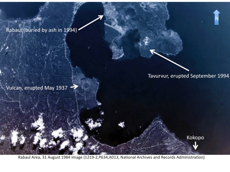
(Unused reference) Page photograph (scan) from Company B, 594th EB&SR, Chapter 4. Christmas 1944 with 5th Australian Division at Jacquinot Bay, East New Britain. – Aussies always throw a good party – 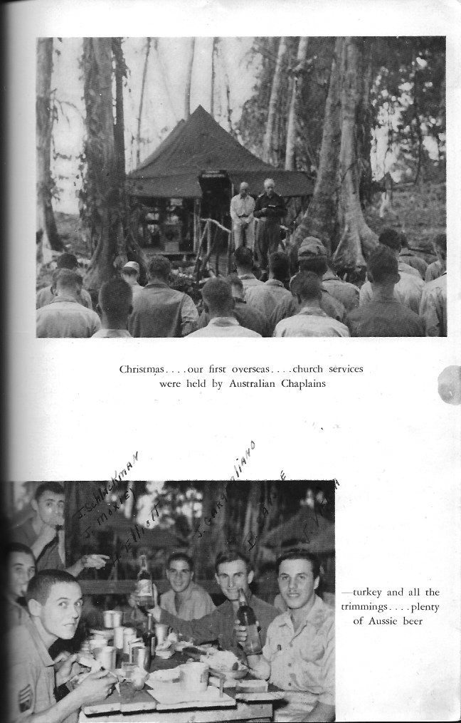
Illustrations:
Overview Map: Project-annotated US Geological Survey map section of New Britain Island (screen capture), 2016.
New Britain campaign map: Project-annotated US government public domain map of New Britain Island.
Part 3 Notes and References
Text:
David Billings research and analysis, interviews with Australian Second World War patrol members, and records of the Australian War Memorial archives.
Images:
Top Banner: Photograph (cropped) of SWPA aerial reconnaissance tracks map: OCE, GHQ, SWPA, Annual Report 1943. National Archives and Records Administration. – Aerial photographs from 1943 were used to produce the map used by the Australian 11th Battalion – 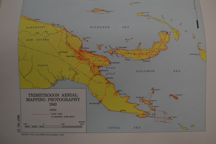
Photograph of Captain Mott (with others) and text from Australian War Memorial, 084140, online.
Photograph (aerial) of East New Britain, Frames 96-98, Mission 137X, 8th Photographic Squadron, altitude 20,000ft, 6-inch focal length, 18 May 1943. National Archives and Records Administration. 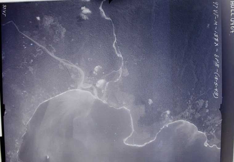
Illustrations:
Mevelo River Area Map: Project-annotated map section, 13th Brigade Records, 1945. Australian War Memorial, RCDIG1023038, online.
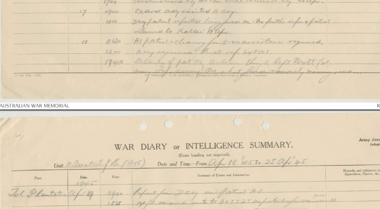
(Unused reference) Captain Mott figured prominently in the after action report for Patrol A1 as can be seen in the April 1945 War Diary/Intelligence Summary – entry for 18 April, 1742 hours (right side – Capt Mott). Australian War Memorial, RCDIG1026942, online.
Part 4 Notes and References
Text:
David Billings research and analysis. Correspondence, audio/video and interviews with the Australian Second World War veterans. Holdings from the US National Air and Space Museum, PNG Modern History Museum, Australian War Memorial, Pima Air Museum, and New Zealand Museum of Transportation and Technology were consulted.
Images:
Top Banner: Wall-section of Kokopo Military Museum, Project photo archives 2016.
Photographs of four of the veterans: Don Angwin, 1994.
Photograph “Dense Jungle Hinders Search Effort,” Wide Bay jungle, Project photo archives, 2015.
Photograph “One of Many Insects Infesting the Jungle,” Wide Bay jungle, Project photo archives, 2015.
Photographs of Electra 10A Engines: Pima Air Museum and New Zealand Transportation museum, 2013-2016. Examples shown are nearly identical to Earhart’s Electra 10E (engine cowling). 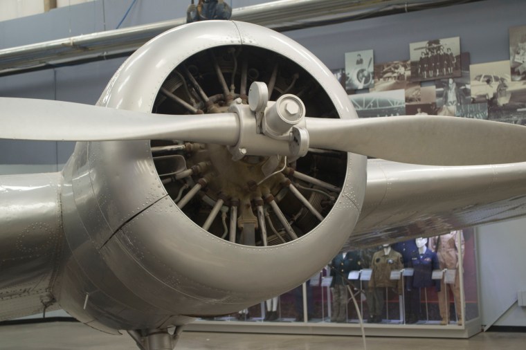
Photograph of Electra Model 10A under construction: George Carson Carrington, “Amelia Eahart, What really happened at Howland”, Page 88.
Photograph Pratt and Whitney engine badge, National Air Space Museum, Project photo archives, 2015.
(Unused References and not shown) Photographs of Lockheed Electra 10A and 10E from various sources.
Illustrations:
Message Form image: 19 April 1945 Message Form from 11th Infantry Battalion. Australian War Memorial, RCDIG1026942, online.
Map section: Bottom portion of the 11th Infantry Battalion operations map, USACE, 1:63,360 scale, 1943, Project holdings.
Sketch/drawings: Sketches by David Billings with words and written responses by Keith Nurse, 1995.
Backhouse’s Sketch of Aircraft Wreckage, Ken Backhouse on request from D. Billings, circa 2000.
Part 5 Notes and References
Text:
David Billings research and analysis, and interviews with Australian Second World War patrol members. Correspondence with David Menard. Earhart flight and radio references are public record.
Images:
Top Banner: Photograph of Kokopo night moon, Project photo archives, 2015.
Photograph Luke Field Crash, AP, 20 March 1937.
Images of messages and reports in the 20 May 2020 addendum, AWM digital archives, March-April 1945, 11th Battalion Records (primary).
Photograph of “J” Boat, New Britain, AWM, 27 January 1945
Photograph of CAC Wirraway engine: unsourced.
Photograph “Examining WWII Aircraft Wreckage at the Kokopo Military Museum,” Kokopo, Project photo archives, 2015.
Photograph of Swamp Ghost, Pacific Aviation Museum, Project photo archives, 2012. MACR reports from National Archives and Records Administration.
Illustrations:
Map section (2): Bottom portion of the 11th Infantry Battalion operations map, USACE, 1:63,360 scale, 1943.
Lockheed Aircraft Report Number 487: Lockheed Aircraft Corporation publication via Oscar Boswell.
Table of Opportunities: David Billings research and analysis. Australian War Memorial.
(Unused references): Use of zinc chromate primer in 1936, 1937. The aircraft yearbook for 1936, 1937 and 1938, ACCA, New York. Internet histories.
Part 6 Notes and References
Text:
David Billings research and analysis, and interviews with Australian Second World War patrol members. Earhart flight and radio references public record and Purdue University archives. Radio and weather messages from TIGHAR data archives.
Images:
Top Banner: Photograph (cropped) of aerial reconnaissance tracks across Gazelle Peninsula, 21 December 1948. 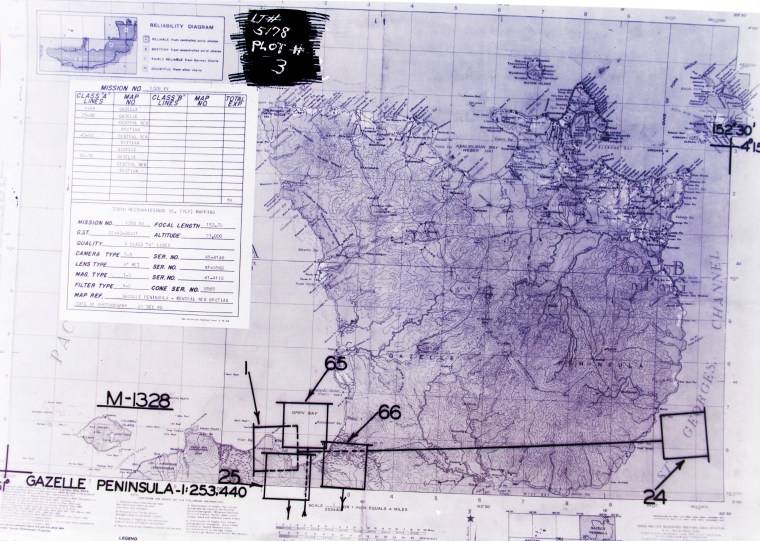
Wind map: Photo of Project annotated Wind Chart, US Navy Climatic Atlas, V3, July 1968.
(Unused reference): Photo of Ontario USCG vessel. Janes All the Worlds Ships, 1939.
Illustrations:
Map of Choiseul: Project annotated Solomon Islands Tourism Board map, online, 2015.
Map of Nukumanu: Project annotated Sheet 1788, 1:50,000 scale, RASC, 1980.
Vector Diagram: David Billings, 2015.
Wind map: Section of USN Marine Climatic Atlas, historical wind patterns for July, up to 1968.
Earhart Long Range Plan Chart: David Billings analysis using MS Excel spreadsheet, 2016.
Part 7 Notes and References
Text:
David Billings research and analysis, and interviews with Australian Second World War patrol members. Correspondence with Ron Bright. Earhart flight and radio references public record.
Images:
Top Banner: Photograph of Lae Airfield, Target Materials, 1944. National Archives and Records Administration.
Illustrations:
Wind chart: 1943 to 1945 average surface wind-drift, University of Texas library, online.
Wind map: Section of USN Marine Climatic Atlas, historical wind patterns for July, up to 1968.
Highlight map: Area of Interest West of Howland Island to New Britain. USG Map 1943.
Speculative Return Track Map : South-Central Portion of the Gilberts with speculated Electra route, Google Earth map background, 2016.
Earhart Long Range Plan Chart: David Billings analysis using MS Excel spreadsheet, 2016.
Part 8 Notes and References
Text:
David Billings research and analysis, and interviews with Australian Second World War patrol members. Earhart flight and radio references public record.
Images:
Top Banner: Section of Admiralty chart vicinity New Britain, date unknown. National Archives and Records Administration.
(Unused reference): Mortlock island aerial photograph, National Archives and Records Administration.
Illustrations:
Speculative Return Track Map, Tabiteuea to New britan, Project annotated track over a Google Earth map screen capture, 2016.
Earhart Long Range Plan Chart: David Billings analysis using MS Excel spreadsheet, 2016.
Part 9 Notes and References
Text:
David Billings research and analysis, and interviews with Australian Second World War patrol members. Earhart flight references are public record. Molkolkol information from “Hostages to Freedom, the Fall of Rabaul,” Peter Stone, 1995, pages 22-23, 102. Interviews with Pomio people were frequent since 1994.
Images:
Top Banner: Photograph of helicopter landing near 2015 camp site, Project photo archives, 2015.
Photograph “Wide Bay beach looking towards Tol Plantation,” Wide Bay, Project photo archives, 2012.
Photograph “The dense jungle made visibility difficult even for short distances,” Wide Bay jungle, Project photo archives, 2015.
Photograph “Massive trees covered with “strangle” vines are a common sight,” Wide Bay jungle, Project photo archives, 2015.
(Unused references and not shown) Photographs and images of the East New Britain wreckage search area. Search maps and area limitation studies. 2015 Project archives.
Illustrations:
(Unused references and not shown) Search area limitation studies.
General References:
“The Sound of Wings”, Mary S,. Lovell, 1989, ISBN 0 09 970870 1 (the best book on the Earhart & Noonan saga…).
“Last Flight”…..by Amelia Earhart…. put together from her notes by Gerge Palmer Putnam, her husband in late 1937, Copyrighted then and again in 1964, the edition I have is 1988. ISBN 0-517-56794-6. This book started me on the “low fuel consumption trail”, eventuating in the Table of Horsepower and Fuel Consumption table that is in Part 6.
“Amelia – a Life of the Aviation Legend” by Donald M. Goldstein and Katherine V. Dillon, 1997, ISBN 1-57488-134-5.
“Amelia Earhart” by Doris L. Rich, 1989, ISBN 0-87474-836-4. This has the information about the 590 USG put into the Electra at Ford Island which can be in support of the low fuel consumption on the Oakland to Wheeler flight. Rich also brought to light the “Contingency Plan” which she indicated was in Gene Vidal’s memorabilia at the University of Wisconsin.
“Wings of Man” by Jack L. King, 1981 ISBN 0-911721-91-6. Deals with the life of Captain Dick Merrill, a many thousand hour pilot on Eastern Airlines. He enters the picture because in May 1937 he and Jack Lambie took “the Daily Express” a Lockheed 10E from NYC with 1040 USG to London with News and pictures of the Hindenburg disaster and brought back pictures of the Coronation of King George VI. They left Blackpool in the N-W of England with a reported 1300 USG (100 USG in cans) and landed at SQUANTUM Naval Base (near Boston) 22 Hours later and still had fuel enough to fly on to NYC. They had flown across the North Atlantic at 5000 feet to avoid icing and the Electra was fitted with leading edge de-icing boots which degraded the aircraft performance. I recall they still had 130 USG at Floyd Bennett Field on landing. Quite a feat. Quite an aircraft.
Part 1 – The Beginning | Part 2 – PNG History/Topography | Part 3 – Wreckage is Found
Part 4 – Tangible Evidence | Part 5 – Analysis | Part 6 -Lae to Howland Island
Part 7 – Howland area to New Britain – To the Gilberts…
Part 8 – Howland area to New Britain – Flying Westwards for Rabaul
Part 9 – Not Seen, But Not Forgotten
Part 10 – 2017 Expedition Overview
References
HOME | Contact
COPYRIGHT 2004 – 2026
The contents of this website are Copyright to David Billings. No portion of this website story may be used without permission. All Rights to the content of this story based on the Earhart Lockheed Electra 10E aircraft being on New Britain Island are Copyright to David Billings and the story is the Intellectual Property of David Billings.
