COPYRIGHT 2004 – 2026
The contents of this website are Copyright to David Billings. No portion of this website story may be used without permission. All Rights to the content of this story based on the Earhart Lockheed Electra 10E aircraft being on New Britain Island are Copyright to David Billings and the story is the Intellectual Property of David Billings.
The Last Flight – Flying Westwards for Rabaul
Nothing visible but the sea. No land, no ships, no birds. Nothing heard on the radio. Only the drone of the engines, monotonously beating the propellers against the air at 10,000 feet.
The continuing hypothesis is that at 2230 GMT 2 July 1937, Earhart and Noonan had left the vicinity of Tabiteuea Island in the Gilbert chain of islands and headed west. The local time overhead Tabiteuea had been 10:30am and the date 3rd July as the International Dateline was behind them.
In about seven and a half hours they should see the Nukumanu Atoll. They have the sun overhead and later they will be following the sun. In two and a half hours they will be abeam Ocean Island and if a technical problem arises they can turn toward the island. Similarly they will be abeam Nauru in three and a half hours.
Their course is the reciprocal of the course they flew the previous night and which is now 250o Magnetic.
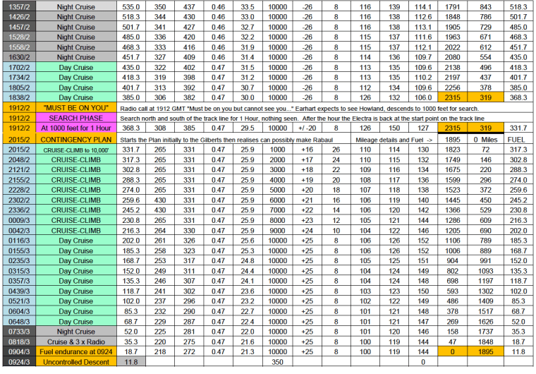
At 0540 GMT 3rd of July, local time 4:10pm on 3rd July, Nukumanu Atoll is showing on the horizon. The TAS is 123 Smph; IAS 103 Smph; fuel remaining is 107 USG and the fuel consumption is 23.6 USGPH at SFC 0.47. Total H.P. is 302 H.P. with 241 H.P. at the propellers. They fly overhead the atoll at 0550 GMT. Local time by longitude at Nukumanu is 4:20pm (GMT + Ten and a half hours).
The next landfall will be the Mortlock Atoll 170 miles further on their present course. The sun is easily visible in the west.

In 2009, I was working in Papua New Guinea, in Port Moresby, the capital city. I received a telephone call from a pilot friend of mine named Otto Eberl. After exchanging greetings, Otto asked me if I would come down to the Aero Club that evening after work as he wanted to introduce me to a person he had been speaking to the previous evening. I asked Otto what this was about but he just said, “It will be of interest to you, so just come down, David.”
I went down to the Aero Club after work and met with Otto. He walked me over to the bar where a grey-bearded Papua New Guinean gentleman was stood talking with other people. Otto introduced me to the gentleman who it turned out was from the Mortlock (Takuu) Atoll; he was in Port Moresby working as a maintenance man for an Anglican Church. Otto asked the Mortlock to repeat to me what had been said the previous evening about his grandfather. “What about my Grandfather?” said the Mortlock and he looked puzzled. “What you said about your grandfather seeing something over the island.” The Mortlock reflected for a moment as if trying to remember, then looked up and said, “You mean my grandfather being the first man in the Mortlocks to see an aircraft?” “Yes,” said Otto.
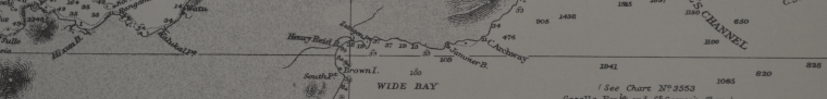
Mortlock Atoll is also known as Takuu Atoll approximately 350 miles due east of New Britain Island. Mortlock Islands (or Nomoi) are found in Micronesia some 675 miles north of New Britain, and are NOT the islands referenced in this story. Mortlock (Takuu) Atoll is part of Papua New Guinea. Mortlock (Takuu) Atoll was and remains sparsely populated and isolated from the outside world.
“My grandfather was the first man on the Mortlocks to see an aircraft. He was the local ‘Polis-boi’ (policeman) back in those days and when I was a boy he would tell me about it.”
I asked the Mortlock, “When was this, did your Grandfather say when he saw it?” He replied, “No, not exactly, except that it was well-before the big fight.” The “Big Fight” in Papua New Guinea parlance is World War Two, never forgotten in Papua New Guinea as their country was the ground over which some of the fiercest fighting ever seen took place.
So here was a report from the grandson of a Mortlock islander in a responsible position on the island of an aircraft going overhead well-before the start of WWII. The Mortlock Atoll lies 340 Sm from Rabaul, the place with the nearest airstrips. There is no airstrip on the Mortlock Atoll to this day so why would an aircraft from Rabaul venture on a 680 Sm round trip, out to the Mortlock Atoll, take a look and return to Rabaul? Seemingly it is a waste of gasoline. What aircraft type would there have been at Rabaul that was capable of the round trip? Only the Royal Australian Air Force Lockheed Hudson aircraft were capable of that flight, out of all the aircraft based in Rabaul, and the Hudsons did not arrive at Rabaul until December 1941.
Earhart and Noonan, in my scenario, would be overhead the Mortlock Atoll at 0700 GMT 3rd July, local time by longitude at Mortlock is 5:40pm (GMT + Ten and half hours). Fuel is now down below 80 USG and the consumption rate is 23 USGPH. The problem now is that with 330 Sm to run to Rabaul, within two hours it will be dark, and they have not been to Rabaul before, and it may be difficult to find. They have covered 1545 Sm since turning back and that has taken ten and a half hours.
From the Mortlock Atoll the shortest way to Rabaul is 330 Sm and, the new course to fly is 270o Magnetic, or they can hold the present course overflying the islands of 265o Magnetic, which will take them to Carteret Reef and around the southern tip of the island of New Ireland. They then should see New Britain Island. Carteret Reef is reached at 0740 GMT 3rd July, at 5:40pm with late afternoon clouds starting to build up. Typically in that region in the late afternoon cloud build up starts and the area is blanketed in a cloud layer at around 5,000 feet. Fuel use is 22.4 USGPH and fuel remaining is 63 USG. They hold their course. With the darkness coming on, they know their best course is to fly until land, until the coast of New Britain is reached.
At 0800 GMT, 6:00pm Local Time, it is dark on the ground with dim light only above the cloud where they are. While the fuel is now down to 45 USG and while there is fuel still going to the engines, the best idea is to drift down at low power. Earhart moved the Pitch Levers slowly forward, retards the throttles and starts descending.
At 0831 GMT, 6:31pm Rabaul time, Nauru hears a radio transmission on 6210 Kcs that was unreadable and with no sound of engines in the background, but the Nauru radio operator said that the voice sounded the same as the voice he had heard the night before at 1030 GMT.
Nauru reported the call as:
“SPEECH NOT INTERPRETED OWING BAD MODULATION OR SPEAKER SHOUTING INTO MICROPHONE BUT VOICE SIMILAR TO THAT EMITTED IN FLIGHT LAST NIGHT WITH EXCEPTION NO HUM OF PLANE IN THE BACKGROUND”
At 0843 GMT, 6:43pm Rabaul time, the radio operator on Nauru hears another transmission on 6210 Kcs, again unreadable, and again without any noise of engines in the background.
At 0854 GMT, 6:54pm Rabaul time, the same transmission happens, an unreadable call on 6210 Kcs, and again, without the sound of engines in the background; heard by Nauru.
Nauru Radio reported these calls to Radio Bolinas in San Francisco who referred them on to Coast Guard HQ in San Francisco who then relayed them on to the USCG Itasca at Howland.
These three calls although “unreadable” were made on 6210 Kcs, the operating frequency that Earhart said that she was changing to at 2015 GMT, and from which a call was heard by Nauru at 2200 GMT, and now Nauru reports three more calls on 6210 Kcs, an aircraft frequency. This, at a time in the evening for the latter three calls, in the nightime… when no aircraft should have been within transmission range of Nauru or for that matter in the Rabaul area or in Australia. Night flying in New Guinea has always been restricted because of the lack of Navigation Aids (even to this day). There is only the one possibility of an aircraft being in the air at that time within the reception range of Nauru and that aircraft was, the Electra.
No more calls on 6210 Kcs were heard after that last call of 0854 GMT.
To me the calls, spaced out as they were, were an attempt at making a contact. Possibly, Earhart tried to contact Rabaul Radio at Bitapaka Radio Station at 6:31pm but by that time Mr. Twycross would have closed the station and Bitapaka did not have the frequency 6210 Kcs in any case. Lae Radio would also be closed at that time.
If these calls had been heard in later years with more air traffic around, anyone hearing these calls would have gone on air and asked the transmitting station if they could relay for them.
If a straight line is drawn from the centre of Nukumanu Atoll and continued through Mortlock Atoll and through Carteret Reef, and which line continues to the west over the coast of New Britain – that line passes over the area where the men of “D” Company 11th Battalion, Australian Imperial Forces carried out Patrol A1 from 15th April to the 18th April 1945. During that patrol they found an unpainted all-metal aircraft wreck with Pratt & Whitney R-1340-S3H1 engines…it did not carry any military insignia and appeared to have been on the jungle hillside for a number of years.
This hypothesis of Earhart and Noonan invoking their Contingency Plan and carrying out a turn back along their reciprocal course, using low engine power at a steady regulated rate for maximum efficiency, declares that there is a connection between the hypothesis and the find of a Pratt & Whitney R-1340-S3H1 powered all-metal aircraft by an Australian WWII patrol in April 1945.

Part 1 – The Beginning | Part 2 – PNG History/Topography | Part 3 – Wreckage is Found
Part 4 – Tangible Evidence | Part 5 – Analysis | Part 6 -Lae to Howland Island
Part 7 – Howland area to New Britain – To the Gilberts…
Part 8 – Howland area to New Britain – Flying Westwards for Rabaul
Part 9 – Not Seen, But Not Forgotten
Part 10 – 2017 Expedition Overview
References
HOME | Contact
COPYRIGHT 2004 – 2026
The contents of this website are Copyright to David Billings. No portion of this website story may be used without permission. All Rights to the content of this story based on the Earhart Lockheed Electra 10E aircraft being on New Britain Island are Copyright to David Billings and the story is the Intellectual Property of David Billings.
