COPYRIGHT 2004 – 2026
The contents of this website are Copyright to David Billings. No portion of this website story may be used without permission. All Rights to the content of this story based on the Earhart Lockheed Electra 10E aircraft being on New Britain Island are Copyright to David Billings and the story is the Intellectual Property of David Billings.
The Contingency Plan
The hypothesis continues and now, the Contingency Plan is invoked at 2015 GMT after the Electra crew have searched for Howland Island for one hour…
First, we must discuss how the Contingency Plan became known and where it was found and the events that happened about the find.
The Notifications of The Contingency Plan
I had first read of a Contingency Plan made for the Earhart flight from Lae to Howland in Mary Lovell’s book: “The Sound of Wings.” A contingency plan is also mentioned in Doris Rich’s book: “Amelia.” Both of these authors attributed the source of this plan to Eugene Vidal, Earhart’s former business partner and a close friend.
As a former aircrew member, this mention of a Contingency Plan was completely logical to me as it is standard practice to have a planned “alternate” to a destination in case of bad weather or in an extreme event such as a blocked runway or natural disaster happening mid-flight. Anyone even thinking about a 2500 mile flight mainly over water would have to be bereft of thought in not considering that some event might cause the flight to need to divert to someplace else in the circumstance of a technical failure or fault in the navigation due to bad weather. An alternate plan makes sense.
Both of the above authors made the case that Vidal had said that Earhart would search for Howland and if not found, she would then head for the Gilbert Islands. Rich also said that Earhart would search until she had four hours of fuel remaining before turning for the Gilberts where she would land on a beach.
Various writers and authors have questioned the propriety of this “Contingency Plan” in the belief that Earhart and Noonan did not have a “Contingency Plan” at all and simply fell beneath the waves, or landed “somewhere” in a disappearing act never to be seen again. The use and/or existence of a Contingency Plan or an Alternate Plan is simply, without proof, dismissed. Some authors want Earhart and Noonan to go astray and end up way off-course to the north during the night, and set down in the Marshall Islands subsequently to disappear. Others want Earhart to go the other way to the south and end up at the mainly uninhabited Phoenix Group, only to die as castaways and their aircraft slide off a reef edge into the deep.
Researcher Ronald Bright of Washington state was featured as a man who has mentioned the Contingency Plan on contemporary forums concerning the Earhart saga. Ron is a well-known researcher who tends to favour the “Crashed and Sank” theory rather than a landfall theory, but has remained open to other ideas or theories.
On 24 August 2000, Ron Bright wrote on a forum concerning Eugene Vidal’s statement (used with his permission):
“Recently I posted Eugene Vidal’s statement that Amelia intended to fly back to the Gilberts if she missed Howland. Both Vincent Loomis and Mary Lovell use that statement in their books but none cited a source.
In Doris Rich’s book, “Amelia” she writes (p.273) that Eugene Vidal said that Amelia’s plan was to “hunt for Howland until she had four hours of fuel left, and then, if she had not located it, to turn back to the Gilbert Islands and land on a beach”. Rich cites Vidal’s claim from the Vidal Collection, box 19, p.97. In the Bibliography she cites the Vidal Collection 6013, American Heritage Center, University of Wyoming, Laramie, Wyoming.
Vidal’s alleged statement was made contemporaneously with the event. And I guess it was no secret that Amelia and Eugene were very, very close friends and confidantes prior to the flight; reportedly Eugene also was involved in some of the planning, etc, and would be privy to that kind of information.
But why in the world would Amelia confide in just Vidal; it would seem that any contingency plan would be made known to Williams, Putnam, and others, including, Noonan. Do any of the charts that she left at Lae show on a larger scale the surrounding Islands. I sort of recall she flew only with a strip map and even the Phoenix Island were not shown???
I personally have not checked with the U of Wyoming re the Vidal collection but maybe someone on the forum has already investigated Vidal’s statement. And even if she did make that plan known verbally to Vidal, exigent circumstances at the time may have caused her to turn south and make a run for the Phoenix as you theorize.
As I recall the Navy searched the Gilberts with no luck and later the Yankee of Gloucester also “searched” to some extent the Gilberts but no luck.
The Gilberts are about 450 miles west of Howland and within range of 4 hours of fuel (150mphX4=600).
My question is how thoroughly were the Gilberts searched by the Navy and are there any other reported indications that she may have reversed course back to the Gilberts. Native folklore, artifacts, radio messages, radio strength, etc?? “
Ronald Bright
The owner of the forum replied in disagreement with Ron Bright to the effect that the Contingency Plan was a “non-event” which the other forum members had previously discussed and rejected. The owner of the forum mentioned that a forum member had been to the University of Wyoming and found nothing in Box 19, and then made a statement that this mention of a Contingency Plan in Rich’s book was, like other writings in the book, “rumor stated as fact.”
Further on to that contentious statement, the forum owner goes on to make assumptions where no proof of their correctness is offered. It is assumed that Noonan had very good charts of the Pacific whereas it has been said often that the National Geographic map of the Pacific Ocean was carried. No mention has been made previously that Noonan carried “accurate” naval charts. If it is known that Noonan did carry naval charts, then I would be interested to see the cite for that statement, and reference numbers to the charts themselves.
In the above post, Ron Bright correctly asks: “…how thoroughly were the Gilbert Islands searched?”… a good question. Despite it being assumed that the U.S. Navy searched the Gilbert Islands, if they had done it thoroughly they would still have been searching there at the outbreak of WWII. It is a task, if done “thoroughly”, which would take years. That is plain to see by looking at the expansive Gilbert Islands (on Google Earth).
In a continuation of his reply to Ron Bright, the forum owner continues (paraphrased):
“…that the single part of the Vidal story that did make sense, was the intention to implement a “Different Plan” when four hours of fuel remained. Four hours is stated to give a twenty percent reserve, which was the normal reserve for long distance flights…”
If the figure of 20% is considered as a reserve out of 1100 USG, the fuel load carried out of Lae…a 20% reserve would be 220 USG. With my latest workings in MS Excel at low AUW (around 10,000 pounds) and using a low power setting which delivers 120 Smph Indicated Airspeed, 142 Smph True Airspeed at 10,000 feet, the fuel consumption gets down to 34.9 USGPH. For 220 USG with, say, 20 USG being unusable, 200 USG of fuel would therefore give 5 hours 44 minutes endurance.
Note: It is not known what the figure in USG was for unusable fuel on the Electra 10E.
Ron Bright continued on the subject of the Contingency Plan and wrote to the same forum on 16 October 2000. In this writing he mentions another well-known researcher, Cam Warren. Cam Warren and Robert Payne were instrumental in finding, saving and publishing the manuscript of Captain Laurance Safford’s book, “Earhart’s Flight into Yesterday.” Thanks must go to all these researchers who continued the chase with persistence…
Ron Bright continued: [my notations]
As you know from earlier postings after several months of hunting, the Assistant Archivist, Carl Hallberg, was unable to confirm the Doris Rich cite of Box 19, p. 97 reference to Vidal’s claim that Amelia told him (hearsay) that if she missed Howland, and still had four hours of fuel left, she would fly back to the Gilberts and land on a nice sandy beach. Numerous other authors cited Vidal’s claim but none provided specific cites except the “Vidal Collection”, University of Wyoming.
Although Dustymiss [another researcher] and I tried to get Rich’s notes, who first reported them “discarded,” Cam Warren finally obtained her notes, and, with that new information, found the reference [the Vidal reference] in Box 40, pages 94-103; and sure enough, on page 96-97 there is Vidal’s recollection of Amelia’s intention. This is a lengthy “oral history” tape now transcribed. I am attempting to find out exactly when the tape was made, transcribed, and to whom it was made. (It was taped after the loss as it refers to Amelia’s remark that she was “running low” on gas when “she should have had 4 hours remaining.”)
As Cam has pointed out that is only an insight into her possible plans, although no other contingency, e.g., Phoenix Islands is mentioned, at the planning stage of the second World Flight. Vidal was obviously close to Amelia, and he says he helped her with her route and maps. A lady can change her mind, and, of course, she was in “exigent” circumstances. Nevertheless, the Gilberts were a strong possibility, based on Vidal’s story. All of us realize that that doesn’t solve the “where” yet, but it confirms there are still records existing out there in archives, and museums that may lead to the solution.
Ronald Bright
Conclusion
But for the persistence of some researchers into the Earhart mystery, assumptions quite often dismiss the actual words said by Earhart – and it would mean that the false assumptions made would prevail and we would be none the wiser. It is a truism that people should never assume that contemporary evidence that pops up from time to time, sometimes quite by accident, is false. All leads to the truth must be scrutinised…
Some people want the Earhart saga to “go their way” of thinking, making assumptions and quite often repeating those assumptions, time and time again and even writing seriously that their assumptions are correct, without any proof whatsoever. False or bad assumptions frequently propagate or compound errors when assessing contradictory information and evidence.
The Contingency Plan was a fact – Earhart intended to turn back for the Gilbert Islands if she could not find Howland in the prescribed time.
Wind Data
Secondly, we must discuss the wind data that is prevalent for the area of the Pacific Ocean near the equator and particularly what the wind pattern is for the month of July. We have seen that the Electra was affected by headwinds as it flew from Lae. I now need to show that the winds over the southern Pacific and the northern Pacific combine to send the winds from east to west during the period of a few months in mid-year. Typical of the pattern is July.
Winds over the Pacific Ocean
The pattern of winds over the Pacific Ocean is well-documented in a series of early charts of the weather conditions some of which are available in the University of Texas.
See: http://www.lib.utexas.edu/maps/historical/pacific_islands_1943_1945/
This early chart dates from the years 1943 to 1945. The winds for July are shown moving from the east to the west.
Howland Island and Baker Island are shown circled. Univ. of Texas Library.

The map above, clearly shows the southeast Trade Winds and northeast Trade Wind movements, and that a continual headwind outbound from Lae in July was a fact.
Generally the winds in the mid-year months run up the west coast of South America and down the west coast of North America and converge at the equator and together form a wind in the equator regions that moves from east to west.
Weather patterns over the Pacific are also documented for 1968 in U.S. Navy material for July:
The position of Howland Island is within the blue circle. Wind tails denote where the wind is “from.” USN Marine Climatic Atlas,V3, 1968, July.
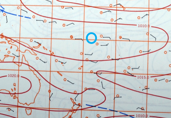
This pattern of wind movement is consistent with the northeasterly Trade Winds and the southeasterly Trade Winds, with winds at the equator moving east to west.
See also: https://en.wikipedia.org/wiki/Trade_winds
We have seen in Part 6 that the Electra, by simple arithmetic, cannot have been close to Howland at 1912 GMT, and according to the MS Excel plot was 320 Sm away from Howland at that time. Earhart and Noonan now descend to 1000 feet in altitude and for one hour, they look for Howland by flying “north and south, on the line 157-337” at 150 Statute miles per hour over the sea, scanning left and right for the island. Earhart radioed that they were “on the line 157-337.” She did not say on a “sunline.”
It has been speculated that Noonan had pre-drawn a line called a “sunline” through Howland Island at 157-337 in True degrees to north which takes into account the fact that when the sun rose at morning, its azimuth was 067o from True North…this would mean that as the sun rose higher the shadow of night would recede as the line of the sun’s light advanced across the surface of the earth making a “line” or “sunline” at 157-337 degrees in True degrees at a right angle (90 degrees) to the 067o True azimuth. Sunrise at Howland on July 2nd 1937 was at 6:15am which converts to 1745 GMT 2nd July. If Earhart was calling “Must be on you…” at 1912 GMT, the sunrise had occurred at Howland 1 hour and 27 minutes previous to 1912 GMT.
What does the phrase mean, “On the line, 157-337,” said by Earhart? First of all, Earhart did not say “sunline” she said “line“…there is a difference. Their track (a flown line) as they approached Howland should ordinarily have been 068o Magnetic but as the wind was forecast to be east-northeast that morning, and Noonan could still check for drift, he may very well have told Earhart to steer 067o Magnetic and the line 157-337 in “magnetic” degrees is 90 degrees to a 067o steered course. Therefore, it would mean an imaginary line, a “line of position,” at right angles to their present course in magnetic degrees of 157 and 337.
See link: The difference between Magnetic and True North.
At 150 miles per hour for one hour total, they can fly for 15 minutes to the north or south, then turn around and come back to where they started in 15 minutes, then continue across the original track line for 15 minutes and then turn around and come back to the “near” original point where they started, one hour previous. Four 15-minute “up and down the line” periods mean one hour expended.
They had seen no sign of Howland or any landfall at all. They cannot continue flying up and down in the same area expending fuel. To move along the track line for 15 minutes to the east and then do another “line” at 157-337, will expend another 48 USG of gasoline. Without any sign of land anywhere at 2015 GMT, they have to invoke whatever plan they made for such a contingency and get out of that area. They are now in an amount of strife, out of which they must escape.
The Contingency Plan was quite simple, if Howland Island could not be found, “Return to the Gilbert Islands…”
Why the Gilbert Islands?
The flight of the Electra from Lae to Howland and the timing thereof, brought the realisation that it was essential to arrive at Howland in daylight with the window for arrival being within reasonable bounds of 8:00am to 4:00pm, to give buffers either side of these times that would exclude the hours of night into dawn at Howland or gathering darkness or night itself after 4:00pm. This window would cater for delays. Therefore, the “setback” of the eighteen to twenty hours the flight would take, depending on weather, winds and unforeseen circumstances, was counted backwards from the 8:00am time 2nd of July at Howland which was 1930 GMT 2nd July and a time of the “1930” less the 18 to 20 hours of the flight gave a result of 2330 GMT 1st July to 0130 GMT 2nd July as a window of time for the take-off. It was then realised that if the flight left at 0000 GMT on the 2nd July, the timing of the flight hours would be coincidental to the GMT times, five hours into the flight would be 0500 GMT and so on.
The take-off time then became fixed at 0000 GMT 2nd July which in local time at Lae was 10:00am. Arrival in 18 hours and 30 minutes would be at 7:00am local time at Howland, being coincidentally 1830 GMT July 2nd, eighteen and a half hours later. This time being 45 minutes after sunrise at Howland.
If the Electra crew did not find Howland due to bad weather, winds blowing them off course, or headwinds making them short of Howland…if the navigation of the Electra failed for any reason and the crew became lost then a simple recovery back to a known position was vital. As stated previously, “high, very high” on the agenda would be the saving of the Electra. If the Electra could be saved, all would not be lost.
There is an old axiom in aerial navigation that if a crew is lost and do not know where they are and have no means of finding out where they are, then they cannot navigate to anywhere. Meaning that from an “unknown” location, an aircraft crew cannot look at a map and say, “That is where we need to be…” because without knowing where they actually are, they cannot “steer” to the position where they would like to be. They are in effect, lost.
As people do, for instance when finding themselves lost in a big city, they backtrack to retain a semblance of direction. The Contingency Plan that Earhart formulated was no different to this simple solution. “Backtrack to the Gilberts” became the plan.

From the maps, Earhart and Noonan both knew that behind them, back along the track they had flown was a long string of islands called the Gilbert Islands. The circumstance of the Electra flight was that, as far as we know, all possibility of Astro Navigation during the night from 1415 GMT onwards, had been impossible and the Electra was being navigated by historic data. For 800 statute miles from 1415 GMT onwards, towards the target of Howland Island, the possible margin for error lateral to the target of Howland Island was 10% or 80 miles. They could be a maximum of 80 miles to the north of Howland or 80 miles to the south of Howland Island. The spread of the Gilbert Islands is 500 miles and the spread of the islands is roughly north-south which is across the outbound track and still across any return path. The 500 miles spread of the islands easily covers the possible spread of a 160 mile error. It simply is…”the best bet.”
Without Astro Navigation at night, it is not possible to gauge wind strength or direction and therefore over the 800 miles from 1415 GMT the wind could blow stronger or less strong making knowledge of where they are on the 068 degree Magnetic track line approach to Howland impossible to predict. An error of 15 Statute miles either way in their position on the track line could be incurred by an increase or decrease in wind strength of 3 miles per hour over the five hours from 1415 GMT to 1912 GMT. In the event of not finding Howland and a contingency “alternate” of an island in a south-southeast direction to the widely scattered Phoenix Group with “no information” of an accurate position on the track line, is decidedly unwise. The Marshall Islands to the northwest also do not offer a certainty of landfall under similar circumstances and they are as far away as the Gilbert Islands.
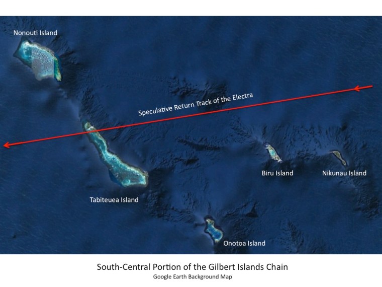
It is with some surety that a turn back for the Gilbert Islands will bring a landfall even though the distance thought by Earhart is 600 miles in her thinking that she, “…must be on Howland…” In fact, from Howland, the closest of the Gilbert Islands was Nikunau Island at 500 Sm and then Beru Island at 540 Sm to the west…before the main chain of the islands begins at 600 miles distance. Two large islands in the Gilberts lay either side of the track line – Tabiteuea Island slightly to the south and Nonouti Atoll to the north. The view to the horizon should show as a dark line as the Electra approaches the Gilberts.
An extraordinary piece of evidence
Fred Goerner, noted KCBS Radio Broadcaster based in San Francisco became an avid researcher of the Earhart saga and investigated multiple theories concerning the disappearance. He spent considerable time following up leads on Saipan where some theorists say Earhart supposedly died of ill-treatment by the Japanese. In 1966 he wrote a book called, “The Search for Amelia Earhart” and it became a best-seller. Goerner writes in that book that he was given access to U.S. Navy files and reports on the circumstances of the U.S. Navy involvement during the search phase for the Electra, and later supposed sightings of Earhart in various places.
During one such visit to a U.S. Navy office in the Pentagon, Goerner writes that he was looking through a U.S. Navy folder concerning a previous report he had read when he came across another message within the folder. He writes that, “Near the bottom of the thick folder another piece of evidence had been added….” Goerner then writes that a terse U.S. Navy message with no heading stated that at 1030 on the morning of the disappearance the radio station on Nauru Island had heard a message from Earhart on 6210 Kcs (her stated frequency) which said, “Land in sight ahead.”
Goerner continues, “I blinked my eyes. Nearly two hours after Amelia had supposedly run out of gas a radio station in the British-controlled Gilbert Islands had heard her voice.” Goerner then wonders why this message had not been included in the search plan in 1937 and “what” land had she sighted? Was there any more to the message? Apparently, there was not, for Goerner does not mention this extraordinary piece of evidence again.
If we take a dispassionate look at what Goerner wrote it boils down to what can be called a ‘large gaff’ on someone’s part in not paying attention to this piece of evidence:
1. The time of the supposed “running out of gas” has, for many years, been put down as 2014 GMT or very shortly after that time, according to some authors, after which time, Earhart was supposedly not heard from again. 2014 GMT is the time at which Earhart and Noonan would have completed their one-hour-long search at 1000 feet for any trace of land. It was the timing of the supposed “last” message recorded from Earhart by the USCG Itasca.
2. As the US Navy message from Pentagon was timed-stamped at 1030, and as Goerner writes, “nearly two hours after running out of gas,” we can safely say that the “1030” refers to USCG Itasca local time which was the same as U.S. Navy local time. The time “1030” on the morning of the disappearance does not fit with GMT, Howland time, Honolulu time or San Francisco time. The time of 1030 local in U.S. Navy time is 2200 GMT and 2200 GMT is one and three-quarters of an hour, i.e; “nearly two hours after”, the 2014 GMT call by Earhart.
3. At 2014 GMT, Earhart had radioed that she was changing to 6210 Kcs as a working frequency and would be listening out on that frequency. Nauru heard the call on 6210 Kcs.
4. Could the “1030” have been confused as the 1030 “GMT” of the previous night’s “Ship in sight ahead,” heard by Nauru? There are three differences:
i) The 1030 in GMT time of that call is 11:00pm local time on the USCG Itasca on July 1st, the night before the disappearance.
ii) The 1030 GMT call heard by Nauru was “ship in sight ahead”, (heard the previous night) not “land in sight ahead.”
iii) The call at 1030 GMT call heard by Nauru was on 3105 Kcs, Earhart’s “night” frequency and the call “land in sight ahead” was heard on 6210 Kcs, Earhart’s “day” frequency.
5. The USCG Itasca did not hear this message reported by Goerner at all, for there is no record of this; the call was apparently only heard by Nauru Radio. Could that then mean that the broadcasting radio station that made the call on 6210Kcs, be closer to Nauru than it was to Itasca? Not necessarily, but Itasca was heavily engaged in radio traffic after the supposed loss at 2014 GMT and may very well have blocked the message by their own broadcasts. I am saying that by 2200 GMT the Electra was flying to the west and had been doing so for one and three-quarters of an hour. The Electra was already 562 Sm to the west of Howland.
6. What land could have been sighted? I have shown in Part 6 that Earhart and Noonan could not have been near to Howland when they thought they were near to the island by the call made at 1912 GMT,“Must be on you.” The word “must” in that call imparts a message of hope – a hope that they were indeed close to “coming on to” Howland Island. That call is indicative of their thinking but as I have discussed, according to the Ms Excel plot, they were in fact 320 Sm away from Howland. On the MS Excel plot at 2200 GMT, Earhart, Noonan and the Electra have already turned towards the Gilbert Islands in accordance with the Contingency Plan and are now 562 Sm to the west of Howland heading towards the Gilberts islands and are seeing the dark outline of Tabiteuea Island, 38 miles ahead.
Is It Possible They Were Seeing Tabiteuea Island?
Tabiteuea Island is 600 Sm from Howland Island and at the turn back point it is 280 Sm distant to the west. The Electra is in Cruise-climb and it will be at 3300 feet at 2200 GMT. It is on the climb back to 10,000 feet where Earhart and Noonan knew that on the way out, they had been subject to a headwind, in a turn back to the Gilberts they will have a tailwind. At 10,000 feet the tailwind will be greater and the aerodynamic drag on the Electra will be less than down at low level. First off, they have to climb to that altitude.
By 2200 GMT the Electra has covered 240 SM from the turn back point at 2015 GMT, and is about 38 Sm away from Tabiteuea Island, the first large island in the Gilbert chain. Nikunau Island and Beru Island (two small islands) lay 180 and 210 miles from the turn back point respectively and also were 30-40 Sm south of the outbound track (and now reciprocal track) and may not have been seen.
The first island in the Phoenix Group in the opposite direction to the southeast from the turn back point is 540 Sm away – McKean Island…so the “land in sight” at 2200 GMT is not there, and they would not have reached that point, and in fact would have travelled less than 220 Sm by 2200 GMT, flying to the East into a headwind component.
Can Fred Noonan navigate now on seeing some land?
Yes, Fred can navigate because he will have studied the positions of the islands close by the outbound track line. Any navigator worth his salt would study the route to fly to ascertain diversions or possible landing places in case of technical difficulties with the Electra.
The 1936 National Geographic “Pacific Ocean” map carried a myriad of framed insets around the central portion showing the detail of islands and the latitude and longitude of the areas. Frame Inset No. 69 shows the Gilbert Islands and there are Latitude and Longitude scales that Fred could work with. That would be ample information for Fred to identify which island lay ahead.
Fuel
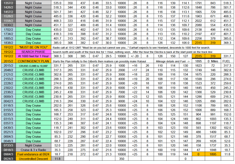
At turn back, how much fuel remained? 331USG remained at turn back at 2015 GMT. At 1912 GMT the Electra still carried 368 USG and the “search phase” at 1000 feet used 37 USG, leaving 331 USG at turn back at 2015 GMT. Earhart starts a slow cruise-climb at a set power regime of 331 H.P. total that uses 25.9 USGPH and is set to give 114 Smph TAS, the best L/D speed for the AUW at an altitude of 1000 feet. Earhart lets the Electra climb very slowly as this will eventually get an advantage from the tailwind at a higher altitude. As weight burns off, the Electra will also fly faster. Earhart is still trying to conserve fuel as she thinks she has 600 Sm to run to the Gilbert Islands. Earhart may need to use fuel to find a more favourable area on one of the Gilbert Islands to crashland the Electra. Earhart will expect to see the Gilbert Islands in around 5 hours time.
As discussed, at 2200 GMT they are seeing Tabiteuea Island in the distance. At 2215 GMT, Tabiteuea is showing under the nose of the Electra as 280 Sm have been covered and the fuel remaining is 278 USG.
Decision Time
It is now decision time. They are overhead Tabiteuea with 278 USG of fuel.
At the present rate of fuel consumption and if 20 USG of that total amount is unusable fuel, the Electra and crew can fly for 10 hours to this unusable fuel level. In the least they will have 10 hours of fuel in the current conditions and if all the points hold – Speed, Wind, Fuel and the Technical Serviceability of the Electra – they can range for at least 10 hours and at the present G/S will add another 1360 Sm to the 280 miles already covered since leaving the turn back point at 2015 GMT. However, for maintaining the best L/D TAS, the power will require to be gradually reduced over that that ten hours and a possible average G/S of 130 Smph will have to be contemplated as the power is reduced and also, the tailwind may decrease. Fuel conservation will improve as the power is reduced to maintain the best L/D speed at the lower weights. A reduction of G/S to 130 Smph will mean a future range of 1300 miles to add to the already completed 280 Sm overhead Tabiteuea. This 1580 Sm total range will bring Nukumanu Atoll easily within the range of the Electra with possibly more miles available after that. It is then realised that Rabaul, with two airfields known about, is possibly within range. Fuel consumption can only get better as the AUW decreases, hour by hour. They have a few choices:
Choice No. 1: This is to continue on to the west…knowing that if they continue ahead they can perhaps reach Rabaul with the two airstrips there and before they get there, if they have to divert to Ocean Island or Nauru, they can do that. They can also put the Electra down there close to those islands just as the intention in the Contingency Plan was to put the Electra down , at the Gilberts, on a cleared area, on a beach or ditch close to shore. The Nukumanu lagoon is within reach at just under 1100 miles distance, they can get to there also. After Nukumanu is the Mortlock Atoll, then Carteret Reef, Nissan Island, New Ireland and then Rabaul with its two airstrips. All places to do exactly the same thing as was planned for “a contingency” but previously to be at an island in the Gilberts, now there is “10 or so hours endurance” and that island landing may have to come later.
Choice No. 2: Overhead Tabiteuea, turn around again and head back for Howland Island 600 miles away. With 278 USG, 5000 feet of altitude and at 130 IAS and the TAS of 143 and a headwind of 23 Smph the G/S will be 120 Smph, the flight will take 5 hours and use 160 USG, leaving 118 USG overhead Howland. If they miss Howland again, they will have to search until fuel exhaustion, for there will not be enough fuel to turn back for the Gilberts or indeed, anywhere else; they will have to ditch the Electra.
Choice No. 3: Overhead Tabiteuea, with 278 USG, fly for a maximum of eight hours along the Gilbert Island chain, looking for a clear area to put the Electra down in order to try to save it. Bearing in mind that a crashlanding or a ditching now, may result in fatalities or serious injuries with very little likelihood of medical assistance. Tarawa, the seat of local government in the Gilbert Islands is 200 miles away from Tabiteuea, and with no formal landing ground there either, would the situation at Tarawa be any different to the situation at “overhead” Tabiteuea?
Choices 2 and 3 mean a few things immediately: The “high agenda” point of saving the Electra will be lost to Earhart and on top of that, serious injury is possible, entrapment in a sinking Electra is possible or fatalities in a crash-landing are entirely possible.
Choice 1 gives breathing space, but above all it will be possible to save the Electra if the conditions of flight remain basically the same and they do reach Rabaul.
If Choice 1 fails to bring success then the result in the end is the same as Choices 2 and 3; the Electra is lost and possibly so too are Earhart and Noonan.
They decide to continue on and set course for Nukumanu Atoll.
The cruise-climb is continued, back up to 10,000 feet of altitude and uses 130 USG total and took 5.0 hours in a slow 30 ft/min climb but which covered a distance of 690 Sm now with the tailwind.
At the TOC point at 0112 GMT 3rd July, the Electra is carrying 202 USG and 690 Sm have been covered and they are at 10,000 feet.
Earhart now selects a power setting to deliver an IAS of 106 Smph which will give a best L/D speed of 126 Smph TAS for the AUW of 9310 lbs. At 10,000 feet this means that a True Airspeed of 126 Smph combined with a tailwind of 25 Smph will give a G/S of 151 Smph. For the exercise of the turn back I used a tailwind value of 25 Smph at 10,000 feet. Horsepower “Available” at the propellers is 261 H.P. and the total H.P. “Required” is 326 H.P. At an SFC of 0.47, the Electra uses 25.6 USGPH.
The power schedule to conserve fuel is to slightly reduce the power at set periods perhaps every half hour as the AUW decreases with fuel burn-off.
They are already over 400 Statute miles to the West of the Gilbert Islands when the top of climb at 10,000 feet is reached. The time and date is 0112 GMT 3rd July.

Part 1 – The Beginning | Part 2 – PNG History/Topography | Part 3 – Wreckage is Found
Part 4 – Tangible Evidence | Part 5 – Analysis | Part 6 -Lae to Howland Island
Part 7 – Howland area to New Britain – To the Gilberts…
Part 8 – Howland area to New Britain – Flying Westwards for Rabaul
Part 9 – Not Seen, But Not Forgotten
Part 10 – 2017 Expedition Overview
References
HOME | Contact
COPYRIGHT 2004 – 2026
The contents of this website are Copyright to David Billings. No portion of this website story may be used without permission. All Rights to the content of this story based on the Earhart Lockheed Electra 10E aircraft being on New Britain Island are Copyright to David Billings and the story is the Intellectual Property of David Billings.
