
COPYRIGHT 2004 – 2026
The contents of this website are Copyright to David Billings. No portion of this website story may be used without permission. All Rights to the content of this story based on the Earhart Lockheed Electra 10E aircraft being on New Britain Island are Copyright to David Billings and the story is the Intellectual Property of David Billings.
Introduction
First, a quote from Amelia Earhart that appears in the book “Last Flight” and of which reflects Earhart’s attitude to the care of her engines. It applies to the take-off from Oakland on the flight to Hawaii, March 1937, where she writes:
“Once aloft, I throttled down. Engines have human attributes – they usually respond to kindly treatment. With a long grind before them I wished to give mine the least possible punishment.”
Exactly. She cared for her engines. I did the same whilst flying, adhering to the limitations laid down by my aircraft, my training and my experience.
I am an Aircraft Engineer and have flown as a Flight Engineer on four-engined turboprop transport aircraft. This chapter of the flight to Howland is my opinion and my interpretation of the operational and navigational aspects of the flight. It is a hypothesis that interprets and uses what knowledge we do have of that flight.
I am not a navigator and I only know a few basics about the art but I have read over and over, the story of the last flight that Earhart and Noonan made and it seems to me that there was a vast difference on this flight with the operation and the navigation compared to the previous successful flights. That is not to say the difference was caused by the navigator, but I am saying there are “circumstances surrounding the flight” that changed the “navigational aspects” of the flight.
What caused that difference? Why did they not reach Howland? Why then did the flight fail?
We cannot know for certain about the actual important data about the wind and weather conditions that existed aloft along the route flown but we do have some atmospheric data from ground stations before the flight as well as from historical records and ships logs. We do not know what the cloud cover was except for Earhart’s brief radio messages but it does appear that there were overcast conditions after the flight reached the U.S. Navy vessel Ontario at roughly the halfway point between Lae and Howland.
At a set Cruise Power to deliver a “cruising speed,” the wind speed and the wind direction would modify an “expected speed” over the Earth’s surface (ocean) at the cruise power setting and the wind values affect the accuracy at the target destination which was obtained, and therefore, would also govern the times taken to reach landfalls where they were available or target distances envisaged by the navigator as he advanced his navigational plot along the route as the aircraft flies on…
I can offer a hypothesis of what happened but it will probably never be known for certain what happened to cause a failure to reach Howland because of a lack of pertinent data. We can give estimates and proposals that the winds and weather encountered did interfere with the flight planning of the aircraft. In all this, the all important groundspeed, the speed over the ground or the sea, gives us an inkling or a clue as to what went wrong. The Electra’s groundspeeds, of what we know of them, can be seen to be lower than previously assessed for this portion of Earhart’s journey.
Aviation Acronyms/Abbreviations
In reading the text, the acronyms used widely in aviation are used. Aviation is loaded with abbreviations for aviation terms…I have added some of my own and here are the abbreviations used in the text:
ABBREVIATION |
DEFINITION |
| A/C | Aircraft |
| ALT | Altitude |
| APS Weight | Aircraft Prepared for Service Weight. A/C Empty weight+Unusable Fuel+Oil+Equipment |
| AUW | APS Weight+Fuel+Crew and Baggage (Plus Passengers if any) |
| B.H.P. | Brake Horse Power – also referred to simply as “H.P.” |
| Cruise Power | A Power Setting made to produce a Cruising Speed. See more on Cruise Power in Note below |
| ELRP | Earhart Long Range Plan |
| ETA | Estimated Time of Arrival |
| FP | Flight Plan |
| GMT | Greenwich Mean Time |
| G/S | Groundspeed |
| H.P. | Horsepower (HP) or Brake Horse Power (BHP) |
| H.P. Required | The total H.P. required to overcome the aircraft aerodynamic drag at a given speed |
| H.P. Available | The Thrust H.P. available at the propellers at a given speed (a percentage of the H.P. Required) |
| H.P. Excess | The difference between The H.P. Required and H.P. Available, which can be used for climbing |
| IAS | Indicated Airspeed |
| ISA | International Standard Atmosphere |
| Knots | Nautical miles per hour (1 Nm = 1.15 Sm) |
| Nm | Nautical Miles |
| MAP | Manifold Absolute Pressure (in lbs/square inch)[pressure of the air/fuel mixture into the engine] |
| PR | Position Report |
| RPM | Revolutions per Minute |
| SHF | Steady Horizontal Flight |
| SFC | Specific Fuel Consumption (lbs. per H.P. per hour)(a.k.a. Brake Specific Fuel Consumption) |
| Sm | Statute Miles |
| Smph | Statute Miles per Hour |
| TAS | True Airspeed |
| TOC | Top of Climb |
| TOD | Top of Descent |
| USG | United States Gallons |
| USGPH | USG per Hour |
Note: Cruise Power. The power set for the different distances that occurred during the World Flight falls into two regimes.
One is a regime for the “short” distances where fuel conservation was not a consideration and fuel in tanks was plentiful. There have been comments that Earhart regularly “gulped” 52 USGPH on flights and no doubt this could be correct for the short hops. On these shorter flights, Earhart most probably flew at a height she was comfortable with and set the Cruise Power to what she considered adequate for the distance.
The second regime is the Long Range regime where the Cruise Power is set with fuel economy in mind and once embarked upon was to be strictly followed, otherwise if it was not, fuel economy was forgotten and disaster lay ahead.
Lockheed had flight-tested the Model 10E in the standard passenger configuration in 1935 and produced Lockheed Report 465 and Clarence “Kelly” Johnson’s name features strongly in that report.
Then there is Lockheed Report 487, dated 4th of June 1936, which was written especially concerning the “Long Range Electras” – Earhart’s C/N 1055 and the sister ship C/N 1065, named “The Daily Express.” Flight testing of the Long Range versions would produce the speeds to fly at for economy and these were reflected in the power settings advised to Earhart in several telegrams to her from Johnson, before the “First Attempt” in March 1937. These are the power settings recommended by Johnson prior to the First Attempt and were as follows:
|
LOCKHEED Long Range CLIMB and CRUISE Power Settings |
||||||
| When used ? | Height | Power Setting | Remarks | |||
| RPM | MAP | USGPH | H.P. | |||
| Climb to TOC | 0-8000′ | 2050 | 28.5″ | Up to 100 | 888 | Best Climb Speed ~ 120 IAS |
| TOC then for 3 Hrs | 8000′ | 1900 | 28.0″ | 60 | 824 | Cruise for 3 Hrs at setting |
| Then for 3 Hrs | 8000′ | 1800 | 26.5″ | 51 | 661 | Cruise for 3 Hrs at setting |
| Then for 3 Hrs | 8000′ | 1700 | 25.0″ | 43 | 608 | Cruise for 3 Hrs at setting |
| Then (Climb + 9 Hrs) | 10,000′ | 1600 | 24.0″ | 38 | 552 | Cruise setting for the rest |
Throughout all of the considerations regarding the fuel economy and operating of the Electra Model 10E, there was an over-riding principle in use which permeates every facet of the Flight Planning of the aircraft and that the best speed to fly the aircraft during a Long Range flight is and was “130 Knots” or “150 Miles per hour” True Air Speed.
Conducting Long Range Flights in 1937
It must always be remembered that this flight was in 1937 and when reading about this flight, the reader should cast the mind back into an age which lived without the miracle of the internet or mobile phones, where “super-technology” that we know today was in its infancy. Airfields in remote regions were few and far between and Navigational Aids and Beacons and Air Traffic Control and Rescue Services in remote regions were non-existent. There was no opportunity or method of obtaining a mobile telephone call to a base station 5000 miles away and ask for advice. Hence, in contemplating the same flight as it was then, in what today would be called “an inadequate diorama.” In 1937, adequate and meticulous planning, which was time consuming in the extreme, was required and subject headings were required in order to successfully carry out a long range flight around the world. A “World Flight” which would end with three long flights over water contained few opportunities for positive fixes of location and no real safe diversions within a short distance in case of failing to locate the target.
One major Ocean, the Atlantic, had already been crossed…now, at Lae, in New Guinea and outbound to the east, there were no airfields available to Earhart after passing Rabaul on New Britain Island, until she made Howland Island. There would be no airfields available for the Electra between Howland Island and Hawaii and between Hawaii and California…
Thus we can say, with this in front of her, as she looked to the east from Lae, Earhart was one brave Lady.
| REQUIREMENTS FOR THE FLIGHT PLANNING | |
| Weather Information | As much as can be gathered concerning weather en route. |
| The Route to fly | Not necessarily the shortest route but a route which will have a safe height over terrain or a route which will avoid bad weather. |
| Alternate Landing Grounds | In case of a Technical Problem or failure of a primary Component on board an alternate plan to divert to a landing is developed. |
| Management of Communications | Equipment carried and communications between personnel involved who have to know their duties and what events happen as to ‘where, when and how’. |
| Sufficient Fuel | for the destination |
| Sufficient Fuel | for a Contingency Plan |
| Management of the Fuel | A “Long Range Plan” must be strictly followed |
| Management of Time | The flight is over a widely spaced time difference and crosses the International Date Line |
| Choosing the Crew | A competent Pilot and a Navigator experienced in Astro Navigation, “steering by the stars” |
In today’s world, the adequate and meticulous flight planning needed, is assured by agreement at International Conventions and legislation by National Aviation Authorities. Airline Companies are certified by the National Authorities and airline staff complete all details of Flight Planning.
Weather Information
Weather data and information is critical, particularly the wind strength and direction, and areas of forecasted bad weather.
Before a flight plan can be made and action taken, the weather information must be understood as far as is practical. For Earhart and Noonan, operating at Lae must have seemed like the end of the Earth; with bad communications between centres having a role to play in the flight and weather forecasting being a mixture of magic, guesswork and voodoo. How can a meteorologist based in Pearl Harbour, Hawaii, correctly forecast weather for a flight starting over 4200 miles away at Lae and ending 1900 miles away at Howland Island, having a daylight start, flying through night, and ending in a daylight finish? He did his best and in many aspects he was generally correct; that is all that can be said.
Even radio messages of weather information went by circuitous routes and were dependent on stations being “open” at different times and operators being on shift, and wide awake, and relaying messages on to the next station in Morse Code. There was just not enough information about weather over the vast South Pacific. There were no trending reports or current data on the weather, an undesirable situation that the United States Navy learned very quickly and of which was of immediate concern at the start of WWII in the Pacific.
Some Prior Warning of What Was to Come?
The following issued by a Dutch meteorologist forecast what weather awaited Earhart on the flight from Koepang (in the Dutch East Indies) to Darwin, Australia. The forecast dated 26 June 1937 includes easterly winds “20 to 45” and says:
FORECAST KOEPANG DARWIN EAST TO 20 TO 45 AND GUSTY BELOW 7000 THEN VARIABLE 5 TO 15 CHIEFLY NE TO 11000 SE TO SW 10 TO 20 TO 20000 MAX ESE 2000 TO 5000 MIN ESE 10000 TO 12000 FINE AND CLEAR TO HALF CLOUD CHIEFLY CIST ALST WITH LITTLE CU BASE 2000 TO 4000 OVER FIRST HALF MOD TO GOOD VIS WITH SOME HAZE BELOW 7000
Note: “Clear to half” probably intended to mean to “Clear to half way”… Clouds of “CIST” and “ALST” means Cirrostratus (High Level Cloud) and Altostratus (Medium Level Cloud) respectively.
Was There Any Localised Knowledge of Weather Patterns for the South Pacific?
The Purdue Library “e-archives” Earhart section, contain a 15 Page “General Meteorological Notes” dated 28th April 1937, subtitled “Solomon Islands and New Guinea” on page 1. Page 1 starts with brief notes on the Solomon Islands and half a page of New Guinea notations continuing on to page 2 and “Solomon Islands and New Guinea” ends there. The rest of the pages are concerning the other ports which Earhart was to transit through on the World Flight and the pages are written as if the flight moves from east to west. Obviously, it was written for the World Flight project after the first attempt and considered that the route would remain as for the first attempt. It can only be surmised that these notes came into the possession of the World Flight project and were read.
What Were the En-route Forecasts to Howland that Earhart and Noonan Received?
1. June 30th received from the USCG Itasca in position at Howland:
RECENT CLOUDS CIRROSTRATUS 3/10THS AND SOME STRATOCUMULUS SURFACE WIND EAST 11-19 KNOTS AT 8000 FEET
This report seems to be incomplete but it shows high level cloud cover of 30% and a surface wind from the East of 11 Knots (13 Smph) and 19 Knots (22 Smph) at 8000 feet.
2. June 30th received from Nauru:
NEW NAURU FIXED LIGHT 0.32OS 165OE 5000 CANDLEPOWER 560 FEET ABOVE SEA LEVEL VISIBLE FROM SHIPS TO NAKED EYE AT 34 MILES ALSO THERE WILL BE BRIGHT LIGHTING ALL NIGHT ON ISLAND FROM PHOSPHATE FIELD WORKINGS WEATHER 8AM BARO 29.98, THERM 84 WIND SE AT 3 FINE BUT CLOUDY SEA SMOOTH TO MODERATE
(Barometric Pressure is 1015 mb, Surface wind at 3 on the Beaufort scale = 12 Smph, the Temp = 29oC)
3. June 30th and July 1st, from Tutuila Radio: (American Samoa)
Two U.S. Navy “standard weather code” messages were sent to Lae but there is no knowledge of Earhart understanding what the grouped codes for weather actually meant. One message was concerning the actual weather at the location of Howland and the Itasca and had a plain language section and was received on July 1st:
HOWLAND BARO 28.83 TEMP 78 DEGREES 5/10 CLOUD ACI SURF WIND EAST 13 3000 FT EAST 23 KTS 4000 FT 23 KTS 5600 FT EAST 22KTS
This actual weather shows that the sky above Howland was half-covered in high level alto-cirrus cloud (the cloud cover has increased) while down below at medium heights the wind strength was 23 Knots (26 Smph – an increase), the barometer reading shows a “low” pressure at 976 Mb.
4. June 30th and July 1st, from Pearl Harbour:
Forecast received at Lae on June 30th:
EARHART LAE
WEATHER LAE AND HOWLAND GENERALLY AVERAGE MOSTLY CLEAR FIRST 600 MILES WIND ESE10-15 HEAVY LOCAL RAIN SQUALLS TO WESTWARD ON ONTARIO DETOUR AROUND AS CENTER DANGEROUS CLOUDY ONTARIO TO LONG 175 EAST OCCASIONAL HEAVY SHOWERS WINDS EAST AT 10 THENCE TO HOWLAND PARTLY CLOUDY UNLIMITED VISIBILITY WIND ESE 15-20 ADVISE CONSULTING LOCAL WEATHER OFFICIALS AS NO REPORTS YOUR VICINITY AVAILABLE HERE
FLEET AIR BASE PEARL HARBOUR
Clearly, the meteorologist at Pearl was uneasy about this long range forecasting without accurate local data.
Another forecast received at Lae on July 1st:
EARHART LAE
FORECAST THURSDAY LAE TO ONTARIO PARTLY CLOUDED RAIN SQUALLS 250 MILES EAST OF LAE WIND EAST SOUTH EAST TWELVE TO FIFTEEN PERIOD ONTARIO TO LONG ONE SEVEN FIVE PARTLY CLOUDY CUMULUS CLOUDS ABOUT TEN THOUSAND FEET MOSTLY UNLIMITED WIND EAST NORTH EAST EIGHTEEN THENCE TO HOWLAND PARTLY CLOUDY SCATTERED HEAVY SHOWERS WIND EAST NORTH EAST FIFTEEN PERIOD AVOID TOWERING CUMULUS AND SQUALLS BY DETOURS AS CENTRES FREQUENTLY DANGEROUS
FLEET AIR BASE PEARL HARBOUR
To sum up what Earhart and Noonan did receive showed winds from the east going to 26 Smph at 4000 feet and some high-level cloud which could be a concern for navigation.
What Were the En-route Forecasts for Howland that Earhart Did NOT Receive?
1. July 2nd. From Pearl Harbour, received as Earhart was departing Lae:
EARHART LAE
ACCURATE FORECAST DIFFICULT ACCOUNT LACK OF REPORTS YOUR VICINITY PERIOD CONDITIONS APPEAR GENERALLY AVERAGE OVER ROUTE NO MAJOR STORM APPARENTLY PARTLY CLOUDY WITH DANGEROUS LOCAL RAIN SQUALLS ABOUT 300 MILES EAST OF LAE AND SCATTERED HEAVY SHOWERS REMAINDER OF ROUTE PERIOD WIND EAST SOUTH EAST ABOUT TWENTY FIVE KNOTS TO ONTARIO THEN EAST TO EAST NORTH EAST ABOUT 20 KNOT TO HOWLAND
FLEET BASE PEARL HARBOUR
A wind of 25 Knots (29 Smph) would surely have been of concern if it had been received…
2. From Rabaul, also received as Earhart was departing:
BARO 29.898 THEMO 83 WIND EASTERLY 3 CLOUDY BUT FINE CLOUDS CI CI STR CU CUMI MOVING FROM EASTERLY DIRECTION SEA SMOOTH. NARU 8 AM UPPER AIR OBSERVATION 2000 FEET NINETY DEGREES 14 MPH 4000 FEET NINETY DEGREES 12 MPH 7500 FEET NINETY DEGREES 24 MPH
Again, a wind figure of 24 Smph was never received.
The Nauru (NARU) observations were “actuals” from 3 hours before Earhart departed Lae at 10:00am local time. The barometer is near ISA at 1012 Mb, temperature 28 Deg. C, wind east at 12 Smph but the clouds are cirrus, cirro-stratus (both high level clouds), Cumulus (low level) and “CUMI” – which back then may have been the abbreviation for Cumulonimbus Incus – the anvil shaped cumulonimbus, a towering cumulus which is always to be avoided, now abbreviated to “Cb” today. All these clouds moving in from the east, where the winds from 2000 feet to 7500 feet are recorded as from 14 Smph to 24 Smph easterly. Fine weather, but with winds above 7500 feet of over 24 statute miles per hour. Not exactly what Earhart and Noonan would want.
Altogether, the winds are not favourable for the flight to Howland Island. For the reports that did not reach Earhart and Noonan before they left, the Lae Radio Operator, Harry Balfour, continually broadcast these reports to the Electra but did not receive any acknowledgement that they had been heard.
The Route to Fly
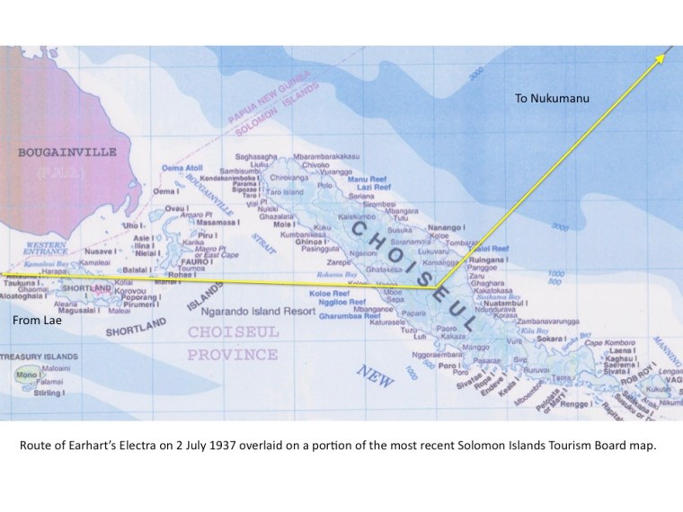
The shortest route is the Great Circle route, basically a straight line from Lae to Howland Island over the curvature of the Earth. However, the weather forecast warned of rain squalls to the east in a region of low pressure 250 miles away from Lae and south of the island of New Britain around the area of Gasmata on the south coast of the island. If a tentative course to the south (around this area where the low pressure weather was supposed to be) had been made in bad weather and an angled approach then commenced to get back on track by Nukumanu Atoll had been made, then Mount Balbi at 8,500 feet on Bougainville Island would have to be avoided, possibly while still in bad weather. Instead of this basic straight line and after receiving the weather forecast, the route was changed to make a diversion around the bad weather and route the flight Lae – Choiseul Island – Nukumanu Island – USS Ontario and then on to Howland Island. The total distance then became 2608 statute miles.
Alternate Landing Grounds
Between Lae and Howland, the town of Rabaul, on New Britain Island, had the only airfields. There were no airfields in the Solomon Islands, Nauru had no airfield, none in the Gilbert Islands and none in the scattered islands to the south of Howland and the Marshall Islands, mandated to Japan, were not open to visitors.
On the way out from Lae, Rabaul offered two formal airfields, one at Lakunai, just to the east of the Rabaul township and the other at Vunakanau on the plateau to the southwest of the township. Vunakanau was a recently opened military airfield. There were a few rough field landing grounds as well.
Therefore, for a diversion/alternate airfield in case of not finding Howland Island, Amelia had developed a Contingency Plan, that she had formulated before her first world flight attempt, and now also would be used for the second if necessary. Amelia had told Gene Vidal, her friend and business partner, that she would turn back for the Gilbert Islands if she could not find Howland Island. She would turn back for the Gilberts to find a cleared area to land the Electra, a beach on which to land, or she would ditch the Electra close to shore. Without a formal landing strip available in the Gilbert Islands therefore, any landing there was likely to be a crash landing.
The reasoning behind this Contingency Plan for a diversion in what would be thought of as being “as against” turning south for the Phoenix Islands which were closer, was that the Gilbert Islands were populated with friendly people and a friendly government, assistance would be available. It is not known whether Earhart even knew of the Phoenix Islands to the south which were not populated, were more remote and to the north, of equal distance to the Gilbert Islands, the Japanese were not welcoming visitors to their mandated islands.
Management of Team Communications
Difficult in the extreme. One of the difficulties was the contacting of personnel and the various factions involved. The Lae Radio Station wholeheartedly supported the flight and the Radio Operator did all he could to assist the crew of the Electra. Radio links by Morse Code and voice had to be relayed through several stations, some in New Guinea, Australia, Nauru, American Samoa and ships at sea. A time consuming and frustrating exercise. Compounding the communications were the U.S. Naval Channels also required, as three ships of the U.S. Coast Guard were allotted as “Guard Ships.” These three ships were to be positioned, one at the halfway point between Lae and Howland, named the USS Ontario, one at Howland named the USCG Itasca and one halfway between Howland and Hawaii, the USS Swan. Their signals were often routed through a U.S. Navy Station on Tutuila, the largest island in American Samoa.
Sufficient Fuel for the Destination
Sufficient fuel had to be carried to reach Howland Island, obviously, plus Contingency Plan fuel. Various total content-amounts of gasoline are stated for the flight. The difference in stated quantities is caused by the requirement for Earhart to use 100 Octane Gasoline for take-off, when 600 Horsepower on each engine would be required. The higher 100 Octane rated fuel used for take-off had more “anti-knock” or “pre-detonation” value than the other fuel available at 87 Octane. Using 100 Octane would allow the full 600 H.P. potential of the engines to be used without causing damage to the engines.
Contents 1: The 100 octane was held in a 97 US Gallon (USG) tank in the left hand wing and by a valve arrangement in the cockpit could be selected to supply both engines. The 97 USG tank was said to hold 50 USG and all other tanks being full, the total possible to be carried by the Electra of 1151 USG was only short by 50 USG, therefore, when the Electra started engines at Lae, it possibly held 1101 USG in tanks.
Contents 2: A simple statement that the fuel load was 1100 USG.
Contents 3: The Lae Refueller stated that he topped off all tanks in the morning before departure, meaning 1151 USG Carried.
Addendum 30 December 2020
The Bob Iredale Letter to Fred Goerner
The writer of the letter below, Robert (Bob) Iredale, was at LAE in 1937 as a representative of the Vacuum Oil Company. The letter confirms to researcher Fred Goerner of CBS Radio in SFO; that Iredale topped off all of the Electra fuel tanks before it took off from LAE for Howland. The letter confirms that all tanks were full, meaning that 1151 USG of fuel were in the Electra tanks at engines start.
793 Esplanade
Mornington
Victoria Aust. 3931
July 28, 1985Dear Mr. Goerner,
Through good work by Australia Post, I received your letter 15 days after your post date of July 11. I am glad to be able to assist your research about Amelia Earhart, as I have read many views by writers, example, spying for the U.S. against Japanese in the Marianas, beheaded by the Japs, still alive in the U.S., etc., etc., all of which to me is a lot of sensationalist garbage.
C.K. Gamble was president of the Vacuum Oil Co., a subsidiary of U.S. Standard Vacuum, when he was a young man. Fred Haig, our Aviation officer, and I knew him quite well, then and later. Up until a year ago I chatted to him about Amelia many times and he recorded the views I’ll relate to you. Fred left the Planet over 12 months ago, hence no response to your letters. He was in his 80s.
Yes, I fueled the Lockheed and did it personally. Fred had arranged 20 x 44 gallon drums of Avgas 80 octane shipped out to us from California many months before. I can assure you all tanks were absolutely full — the wing tanks and those inside the fuselage. After she had done a test flight, I topped them up again before her final take-off. I think she took somewhere around 800 gallons all up. Fred Noonan was with me at the fueling and checked it out. He was also with me when we changed the engine oil, as was Amelia. I enclose a much faded photo, me in white, Fred in brown, and Amelia leaning on the trailing edge of the wing.
You are aware that because of an unfavorable weather forecast from Darwin (some 700 miles SW of Lae), of at least 2 days, Amelia decided on a two-day layover at Lae. She stayed with Eric Chater, General Manager of Guinea Airways, and Fred with Frank Howard and myself at Voco House. Frank and I shared quite a large bungalow as the two representatives of Vacuum Oil in N.G. He died, unfortunately, in 1962. As was our custom, we had a drink in the evening — 90 degrees F, and 95 percent humidity made it that way.
We asked Fred if he would join us the first night, and his comment was, “I’ve been 3 parts around the world without a drink and now we are here for a couple of days, I’ll have one. Have you a Vat 69?” I did happen to have one so the three of us knocked it off. He confessed to Amelia next morning he had a bit of a head, and her comment was, “Naughty boy, Freddie.” That was the only drink session we had, and to suggest he was inebriated before they took off is mischievous nonsense. I can assure you or anyone he had no drink for at least 24 hours before take-off.
We talked a lot about his experience as a Captain on the China Clippers flying from the West Coast to China, and he told us of his expertise in Astro-navigation, amongst other things. We all talked about ourselves, and he showed great interest in our life at Lae. He came around our little depot, where we stored drums of petrol, oil, and kerosene in the jungle to keep the sun off, etc. He told us how keen Amelia was to write a book about the flight, and the different people.
In the two days at Lae, she tried to learn pidgin English and talk to the [natives], and about her ability wherever they landed to take the cowls off the engines and do a Daily Inspection. A remarkable woman, and he has great admiration for her ability. He spent a lot of time with me in Guinea Airways hanger, and around the airfield, looking at the JU31’s, the tri-motored metal Junkers planes that flew our produce and the dredge up to Bulolo, how they were loaded with cranes and all that.
Their final take-off was something to see. We had a grass strip some 900/1000 yards long, one end the jungle, the other the sea. Amelia tucked the tail of the plane almost into the jungle, brakes on, engines full bore, and let go. They were still on the ground at the end of the strip. It took off, lowered toward the water some 30 feet below, and the props made ripples on the water. Gradually they gained height, and some 15 miles out, I guess they may have been at 200 feet. The radio operator at Guinea Airways kept contact by Morse for about 1,000 miles where they were on course at 10,000 feet, and got out of range.
In 1940, I joined the Australian Air Force as a pilot, trained in Canada, and operated in England with the RAF before being promoted to a Wing Commander, commanding an Australian Mosquito Squadron attached to the 2nd Tactical Air Force. I did 70 missions in all sorts of weather, awarded Distinguished Flying Cross and Bar, French Croix de Guerre with Palm for blowing up a prison in France, and other operations for the French. I mention this only as that experience confirmed what I believe happened to Amelia. It is just another view.
The possibility is that they ran into bad weather, 10/10th cloud up to 30,000 feet at the equator, which negated Fred’s ability of Astro-navigation; he would have relied on DR navigation where wind can put you 50 miles off course, cloud base too low to get below it because the altimeter is all to hell if you do not know the barometric pressure, and to see a searchlight provided by a U.S. Cruiser under those circumstances would be impossible. My guess is they got to where Howland Island should have been in the dark, spent an hour looking for it, before having to ditch somewhere within a 50 mile radius of Howland. I find it hard to accept anything else.
I hope I have not bored you. If I can provide anything at all beyond these comments, do write. As long as I am above ground, I’ll reply.
Sincerely,
Bob Iredale
P.S. Can I get your first book in Australia?
These figures given for the fuel loads stated are “hard numbers” or rounded off numbers (except for the 1101) meant to express a figure as an expression of quantity but in actual practical terms the stated numbers could not have been as precise as the figures stated. There would always be a number or two after these because the only indication of contents on the Electra was for the wing tanks. Contents for the fuselage tanks depended on the known capacities. In those capacities were the large diameter filler neck hoses included for instance ? We do not know. The stated figure of “1100” USG out of Lae is based on what Earhart stated to officials at Lae but could have also been 1110, 1120 or any figure around 1100. The tank that held 100 Octane was said to be half full. How was that determined ? Was it “about” half full or definitively measured ? We do not know. Pilots are known to be extremely careful to ensure they “have enough” and very often take more than is needed. A prime example of this was the fuel load for the Electra out of Oakland for the flight to Hawaii in March 1937 where the recommended load was 900 USG but Earhart had 947 USG on board.
Sufficient Fuel for a Contingency Plan
On the First Attempt at the World Flight in March 1937, the fuel load from Oakland was 947 USG and Earhart declared the AUW of the Electra at 14,000 pounds. In one of three telegrams sent to Earhart by Clarence “Kelly” Johnson of Lockheed, Johnson stated that 900 USG fuel load was “ample for 40 percent excess range to Honolulu.” It will be noted, as previously mentioned, that Earhart carried 47 USG on top of the 900 USG which was considered by Johnson as already “ample”…
A 40% excess range over the distance Oakland to Honolulu of 2400 Statute miles gives that an extra 960 miles were available on top of the 2400 distance, making 3360 Statute miles available on the 900 USG proposed by Johnson. Earhart carried an extra 47 USG and this should be adequate for yet another one and a quarter hours of flying at the 38 USG per hour consumption proposed for the final hours of the flight, which itself would take her a further 188 Statute Miles in nil wind. The 947 USG carried should then “be good for” 3548 Statute miles, nil wind.
On the First World Flight Attempt the fuel load which was to carry the Electra the 1900 Statute Miles from Hawaii to Howland Island was also intended to be “enough” to cater for the Contingency Plan to fly on to the Gilbert Islands if Howland as a target, was missed. That is a further 600 miles, making 2500 miles possible on 900 USG. An extended range of just over 30 percent, but readers will note that this was the same fuel load proposed by Johnson for the San Francisco/Oakland to Hawaii flight with its stated extended range of 3350 miles, nil wind.
For the Second World Flight Attempt where the Electra was lost, the Contingency Plan was the same, head for the Gilberts. Turning back along the same track which was used “outbound” is called turning back onto a reciprocal heading and if this was to be done it would present a 500 mile long line of the islands in the Gilberts Islands chain, set almost at right angles to the reciprocal track. Such a target would be “hard to miss” and the Gilberts Islands are the best bet if an aircraft is lost because turning back and heading for a large target like the line of the islands in the Gilbert Islands chain is better than heading off at a stab in the dark (so to speak) of a single island or a group of islands widely separated by sea gaps…which could be missed.
Notes:
1. It is known that Earhart and Noonan carried the 1936 issue of the National Geographic “Pacific Ocean” map. I have a copy of this map. The Pacific Ocean and the lands in it and around it are shown in a central panel, and around the central panel there are smaller framed-panels, 73 small panels in total, showing enlargements of numbered areas on the central Pacific Ocean panel. These enlargement panels show the multitudes of small islands in the Pacific and there are scales of latitude and longitude shown in these small panels which cover the entire outer border area of the large central panel. There is not an enlargement of the Phoenix Island shown in any panel on the entire map. The only indication of where the Phoenix Islands are is on the central panel where they are mere dots and accurate latitude and longitude cannot be discerned. This 1936 NatGeo map of the Pacific Ocean cannot be used for navigation to the Phoenix Islands.
2. The Commander Clarence Williams strip map for the Lae to Howland Island flight does not even show the Phoenix Islands. Even if the strip map did show the Phoenix Islands, this strip map could not be used for navigation to the Phoenix Islands.
Management of the Fuel
Overall then, if 1100 USG was sufficient for reaching Howland and then turning back for the Gilberts represents a 23% “excess range” when previously with smaller fuel loads the Electra was said to be capable of a 30% and even a 40% excess range. In other words, there should have been plenty of reserve fuel available to reach the Gilberts if the fuel usage was managed properly and that, was Earhart’s primary responsibility.
Note: The first World Flight attempt initial flight from San Francisco to Wheeler Field, Hawaii, was fuelled to 947 USG for the 2400 Statute Mile flight and Earhart reported that after completing that flight she still had “…over four hours of fuel remaining…” to search for Oahu at low level which means around 200 USG remaining.
The mass of the Gilbert Islands are 600 statute miles away from Howland Island and to reach them in nil wind at Cruise Power, Earhart would need 4 Hours of fuel at altitude. Earhart should, in a logical sense with the knowledge of past fuel load numbers, have had “far more than 4 hours” of gasoline left with which to carry out this feat. The fact is by the weather report indications, there would also exist a tailwind, if she turned back, requiring less fuel. The Gilberts Islands had no airfields and what Earhart said to Vidal was that she would: “…Find a clear space to put it down, a beach or ditch close to shore”. Therefore, Earhart will also need loiter fuel for that, at low level to do a search for the best place to crashland or ditch. For a Contingency, therefore, I consider 250 USG was the Contingency fuel as a minimum.
Pointers to the Range Capabilities of the Electra
There are several indications that the Electra could fulfill “an Expectation of Great Range,” which is one way to express the capabilities of this aircraft.
1. Commander Clarence Williams prepared a series of strip maps that were for Flight Planning purposes, and all were made for “nil wind” conditions. There is a strip map for each of the proposed flights or sectors of the World Flight. All the strip maps were prepared for an east to west journey but were “reversible” in that they have readings for both east and west directions. One of these strip maps is for a flight from Aden on the south coast of the Arabian Peninsula to Dakar in Senegal, West Africa. The distance is 4307 Statute Miles and the time given for the flight is 28 hours and 40 minutes. In the event, this non-stop flight was never attempted neither east to west nor west to east but the fact remains that the strip map was made for Flight Planning purposes and therefore under certain conditions the flight could be made.
2. The fuel loads that we know of, and the mileages that they were intended for:
a. Oakland to Honolulu: 947 USG for 2400 statute miles which included a 40% excess range, i.e. 960 “more miles” making the total 3360 statute miles on 947 USG. A telegram from Kelly Johnson of Lockheed to Earhart states that 900 USG is “ample” for this flight and the 40% excess range.
b. Luke Field, Honolulu to Howland Island: 900 USG for 1900 miles plus a further 600 miles to fulfill a possible Contingency Plan to head for the Gilbert Islands if Howland was not found.
c. Lae to Howland Island: 1100 USG (or 1151 USG) for 2556 Statute Miles plus a further 600 miles if the Contingency Plan was invoked and a turn-back for the Gilbert Islands was made. Total would then be 3156. Note that this 3156 Statute Miles requirement is less than the range possible on 900 USG of the Johnson telegram mentioned at a., above.
3. On the “First Attempt” flight from Oakland to Honolulu, Earhart made notations that were later put into the book “Last Flight” by her husband George Palmer Putnam. In my copy of the book on pages 33-34, there are notations. There is a section of these notes which are for “6-7 hours out”…at a point 6 hours and 35 minutes into the flight, she writes:
“Harry (Manning) reports we’re ahead of the dead reckoning. Noonan is just figuring position. Gas so far is o.k. The ship now flies like an airplane with almost 2000lbs rt up.”
The letters “rt” in “rt up” in the print font are taken from Earhart’s handwriting and her “r” and “e” are similar. Her handwritten note could have been “et up” which means “eaten up” or perhaps in long form, “used right up,” a phrase which is seldom used in modern times. This indicates that at the 6 hour, 35 minute “into the flight point” or at the latest, the 7 hour point, nearly 2000 lbs of fuel have been used which means “nearly” 333 USG gone. At this 6:35 hour point and according to the Lockheed Long Range Plan, the Electra should have used 413 USG.
By the time of 7 hours it should have used 433 USG. Did Earhart mean to say 433 or 333? It had to be 333 because it is defined by “almost 2000 lbs” and 433 USG weighs 2598 lbs. This could mean that Earhart did not use a high power climb-out but “cruise-climbed” at a lower power setting, thereby using less fuel.
4. The Lift to Drag Ratio: Page 30 of Lockheed Report 487 is set out to give the Sea Level Speeds (in “Vmph“) [Velocity – mph] at the three weights previously mentioned: 16,500 lbs., 12, 900 lbs. and 9,300 lbs. The intention here is to show what the values of the Coefficients for Lift and Drag (CL and CD) are for the speed Vmph at the most efficient use of the aircraft which if we use the data will show us the “Best Lift/Drag Ratio” speed (expressed as VL/D) in order to operate the aircraft at the most economic rate possible.
However, the Lockheed Aircraft Corporation in its wisdom did not include a column showing this Lift/Drag Ratio figure so I have done it for them because it shows that the Electra 10E had a very healthy Lift Drag Ratio.
The best Lift to Drag Ratio for one particular speed will decrease “either side of that one particular speed value,” if a lower speed for the weight, or a higher speed for the weight is used. The VL/D for a particular aircraft weight is an Indicated Airspeed and will stay as the Best L/D if that IAS is maintained as the aircraft climbs and maintains the same weight…which cannot be done as the weight will decrease as fuel is burned. Therefore, the L/D ratio steadily declines as weight decreases as in a cruise and to maintain the lowest drag and therefore the best fuel economy, the speed should also steadily be reduced to match a new L/D Ratio and therefore the power is reduced. This is not done practically in, for instance, airline use, where speed and delivery is of the essence, but it could be employed by an aircraft operator who wanted to “wring out” the most economical way of operating his aircraft.
If a pilot as an operator of a particular aircraft studies the L/D Ratio and tabulates the best L/D speed to fly for a given AUW, then the least fuel will be used because the aircraft will be flying with the least aerodynamic drag. The speed may be down, but the economy will be good.
For the Electra at Sea Level, the tables on page 30 state that VL/D. at Sea Level for a weight of 9,300 pounds is 11.85: 1 (11.85 “units” of Lift for each 1 “unit” of drag) at 110 mph IAS. For 12,900 pounds it is 11.85: 1 at 120 mph IAS and for 16,500 pounds AUW it is 11.9: 1 at 150 mph IAS. All of these specific speeds at the specific weights will deliver these L/D Ratios on the Electra Model 10E. In comparison, a Cessna 150 has a Lift Drag Ratio of 7:1, a Boeing 747 has an L/D of 17:1.
When we speak of remarkable aircraft produced in the 1930’s we very often reflect on the Douglas DC-3 as a magnificent achievement – an aircraft that is still in commercial use today. The Lockheed Model 10E was also an achievement and advanced aircraft for the time, and in the Long Range version it had very, very long legs.
Note: The table on page 30 of Lockheed Report 487 has thirteen typographical errors. I have amended the errors in this table below and have also included the Lift/Drag Ratio figures for different speeds and the three weights of the table.
Sea Level Horsepower Required Curves Data (for Differing Speeds and Weights)
Corrections completed to Page 30 of Lockheed Report 487 and Lift Drag Ratio columns added.
Amended figures from original are shown in Red print

By the use of this table combined with aerodynamic equations, a lot of information concerning the performance of the Electra 10E can be ascertained.
Management of Time
In Earhart’s Lae to Howland flight, the Lae local time was 21 hours and 30 minutes and one day date ahead of the local time and date at the USCG Itasca, the ship that was waiting for her at Howland Island. The Estimated Time of Arrival information is obviously important for the destination to know. In Earhart’s case, a Flight Time of 18 hours and 30 minutes with a take-off time of 10:00 am on the 2nd July (at the Itasca it was 12:30 pm – a half hour after noontime on 1st July) would mean an overnight flight with an ETA at the USCG Itasca stationed at Howland Island of 7:00am, 2nd July; the same date is due to the crossing of the International Date Line at 180 degrees longitude.
The Flight Planning – Lae towards Howland Island
The Flight Planning done for this hypothesis is in Statute miles (Sm) as units of distance and in Statute Miles per Hour (Smph) as speeds per hour…
Earhart’s own system of flight planning, seen previously, to achieve a figure for the duration of the flight seems to be quite simple: Divide the distance by the planned cruising speed in still air, nil wind conditions, of 150 Statute Miles per Hour (Smph), and adjust for what wind information is available. For example in nil wind conditions, the distance Lae to Howland of what was thought to be 2556 Statute Miles (Sm) divided by 150 Smph results in a time of 17 hours and 01 minute and this time for distance is shown on Commander Clarence Williams’ strip map for the Lae-Howland flight and nil wind times are to be found on all the strip maps which were prepared by him for the whole segments of the daily flying regime of the World Flight.
Note: Earhart liked to have speeds and distances in Statute Mile(s) format and this is followed in the text. Where Nautical Mile (Nm) distances and speeds (in Knots) are mentioned, this will be because the flight mentioned a Nm or Knot value and it will be also mentioned here but it will be converted to Sm or Smph and shown in brackets.
Note: Decimal hours are used extensively in modern times for recording the flight times of aircraft in commercial use. Decimal times are recorded as 0.1 for six minutes (6 divided by 60) or as 0.05 for 3 minutes (3 divided by 60). Hence a time of 10 hours 39 minutes would become 10.65 hours in decimal time.
In nil wind conditions this cruising speed of 150 Smph also becomes a Groundspeed (G/S) for it is not affected by a wind as a headwind, tailwind or a wind as an angled quartering or abeam wind, therefore; the cruising airspeed and groundspeed are the same. When an aircraft climbs the Indicated Airspeed (IAS) shown is actually lower than the True Airspeed (TAS) and this TAS can be calculated as 2% of the IAS per thousand feet of Altitude (ALT) and added to the IAS to show TAS. Simplified, an aircraft at 10,000 feet with an IAS of 100 Smph has a TAS of 120 Smph. This “new” speed can be affected by temperature and may vary slightly. Pilots carry a circular computer to display the actual speed of TAS by entering the pressure altitude and the temperature at altitude.
Where there is a wind, however, a headwind value is subtracted from this TAS speed, say of 150 Smph, and the resultant speed is a G/S which will be lower than 150 Smph, conversely, a tailwind value will be added to the 150 Smph speed to deliver a resultant G/S greater than 150 Smph. Not all winds are headwinds or tailwinds but are winds which could and do blow from an angle off to the side of an aircraft as quartering or abeam winds but these winds will have a headwind or tailwind component. The flight navigator faces these wind variations and is constantly alert for changes in speed or direction. The navigator has to be aware of changes to wind angles or he can easily be “blown off course.”
When Earhart received the 12-15 mph headwind and other wind speeds forecasted from Fleet Base, Pearl Harbour, this to Earhart would mean her G/S would be less over the whole flight and in reply to a question from the press as to how long it would take to reach Howland, she replied, “…about eighteen and a half hours.”
This time of eighteen and a half hours is derived by dividing 2556 Sm by 138 Smph (150-12), where “12” is the headwind, the resultant being a time in decimal hours of 18.52 hours or, 18 hours and 31 minutes. A pilot therefore, can work out a flight time such as this and add this to his take-off time so that if an Estimated Time of Arrival (ETA) at a destination is required, he can pass this on to the destination with a calculated time if there is a time zone change because of the distance.
With the weather forecast from Pearl Harbour warning of rain squalls on the Great Circle Route (the “straight line” route) the choice for the Pilot in Command was simple… “Avoid the Storm.” Earhart had already been through one tropical storm in Asia, which had stripped some of the red paint from the leading edges of the wings.
Dividing the distance by the speed for a FP is not quite so simple as that, however, as this is an Estimated Time of Arrival (ETA), an “estimate” only…in flight, the wind may vary from the forecast and a recalculation when the wind is known to vary, will result in a change to this “flight planning” and a new total time derived, leading to a new ETA. Over a long distance flight, this ETA will change several times when differing wind values become known. In modern times a new ETA will be passed forward to the arrival destination as an update or a ground station will relay the new information forward.
To obtain wind values while in the air, a navigator will time a flight over a known distance and periodically check for drift and from landmark sightings can work out the speed of travel over the ground – the Groundspeed. Where there are no landmarks to see while above cloud, the navigator will find his position above the Earth at night by a few star sightings. From the power setting in the Cruise, which in still air will deliver a known speed derived from flight testing, the navigator will know how fast the aircraft should be going in nil wind and when his known position by landmark sightings or his sextant sightings has “fixed” a position on the Earth, the “speed over distance” can be ascertained with a degree of certainty.
Where a distance flown is “not known,” by not obtaining a fix by a known landfall or by a sextant, a navigator is estimating a position from past data, until a next positive fix is obtained. If a next positive fix is not obtained, then a navigator is working blindfolded and using more historical data until a new positive fix is found. That then becomes a stressful time for a navigator.
Not many people pay attention to the early part of the flight, because their attention is riveted to the latter part near Howland. Most people have read for years, that Earhart was lost out there, somewhere over the Pacific Ocean.
Conversely, to me, the early part of the flight is of interest because it seems to have taken an awful long time to get to the half-way point at the USS Ontario and it shows that the winds were worse than forecast. Of particular interest to me was the reason behind the navigation of the Electra resulting in a Position Report (PR) at 0718 GMT which, on Operational Navigation Chart ONC M-15, showed the PR to be 23 Statute Miles to the west of Nukumanu Island, the largest island in the Nukumanu Atoll ring. Noonan had to see Nukumanu Island for a positive fix of his position before nightfall and before they continued on for the best part of 1700 more statute miles to Howland, mostly in the dark, taking sightings of stars for navigation after a firm positive fix at Nukumanu, right on track, outbound to Howland.
In this hypothesis, I am going to clearly state that I have been down this track many, many times before and I could never achieve the targets of distance mileage to a destination along the flight, Choiseul, Nukumanu or the Ontario at the time or near the times given by Earhart if I used the power settings laid out for her by Lockheed as shown in the previous table at the beginning of this part. That is, I could never achieve the distances at the times unless I wound up the headwind values to over 30 Smph, even going to 35 Smph. The Lockheed Cruise Power setting were and are too high for the flight… They are the proverbial round peg in a square hole. So is the Pratt & Whitney “Max. Continuous ” Cruise Power setting, it too does not fit.
What does “fit” as a Power Setting which most accurately agrees with the distances and times of Position Reports and of the sighting of the USS Ontario, half-way in distance to Howland Island – is a lower power setting to deliver the “Best Lift-to-Drag Ratio Speed” in Statute Miles per Hour in True Airspeed throughout the cruise phases of the outbound flight.
This then is the “Best Lift/Drag Speed” plan to be called here, the “Earhart Long Range Plan” (ELRP) and it is followed throughout this Hypothesis. There is a note to add to that however, and that is when Earhart discovered the headwinds were above the forecast wind speeds, then “this” necessitated a rethink which resulted in the “Best Lift/Drag Speed” being used.
Lae to Choiseul – Avoiding the “Low” south of New Britain.
Forecast wind: Headwind of 12-15 Smph from the east. Local rain squalls to the south of New Britain Island (in other words a region of low pressure with tropical rain, something to be avoided).
In planning the flight, the obvious track to Howland, drawn by so many Earhart authors is a straight line from Lae to Howland as a “Great Circle” route – the direct and shortest route to Howland. There is an immediate problem with this “drawn” line straight after take-off from Lae. The line goes over the land to the east-northeast which is to the left of the Electra after take-off when it would be over the Huon Gulf, and that land is high ground with hills to 3000 feet, requiring at least 3500 feet of safe altitude, 30 Sm from Lae. A climb rate of 250′ per minute is required with an aircraft climbing speed of 130 Smph, but when we read the eyewitness reports of the take-off, the onlookers at Lae reported the Electra to still be low over the sea of the Huon Gulf until out of sight. The “straight line,” loved by so many authors, ignores the high ground, and presents a “climbing obstacle” to a heavily laden overweight aircraft.
The AUW of the Electra on take-off from Lae can be worked out from what Earhart said of the weight with 1150 USG on board, which was statement of 15,000 lbs. The AUW can be deduced into two values, from the statements found in the Chater Report, by Eric Chater the Guinea Airways Manager, and the report made by James Collopy of the Department of Civil Aviation. Chater reports one “80” Gallon tank was approximately half full and Collopy writes that one “100” gallon tank was half full. With all other tanks full, this would result in fuel loads of 1110 USG and 1100 USG, respectively.
Therefore with 1100 USG carried the weight would be 14,700 pounds and with 1110 USG carried it would be 14,760 pounds. I shall use 14,700 pounds.
The “long range” Electra 10E at 14,700 lbs was operating above the normal operating weight of a “standard” 10E, which had a certified 10,500 lb. maximum operating weight.
I have stood on the perimeter road at Lae Airport overlooking the Huon Gulf and have seen the 20-25 foot drop-off and the hump in the unmade road that still existed in the mid-1990’s. The perimeter road hump just off the end of the runway, was said to be the source of the cloud of dust that appeared as the Electra wheels ran over the hump on the dirt road and the Electra “leapt” into the air.
We need to know what our “minimum flying speed” (VMIN) is, before we take-off from Lae because we are in the overweight condition and we need to maintain a speed well above VMIN and at least 1.3 times VMIN to maintain a 30% safety factor as a minimum. VMIN in this case is 95 Smph, so, we do not want to be caught under 126 Smph IAS so the power must remain on until we reach a speed at a state of “Steady Horizontal Flight” which I shall call “VSHF.”
After the take-off, the Velocity required for Steady Horizontal Flight at best Coefficient of Lift 0.665 (found from the Lift/Drag Polar of Lockheed Report 487 Page 24) at best Lift to Drag Ratio of 11.85 (from the corrected Page 30 of Report 487), is 203 ft/sec or 137 Smph, so we have a buffer of 11 Smph over our “no go below” of 126 Smph, if we maintain 137 Smph.
This speed of 137 Smph needs a requirement of 448 H.P. at the propellers to overcome the 1227 lbs of Aerodynamic Drag generated by the Electra as it flies through the air but we need a total of 560 H.P. to be available for this because we are only going to get a maximum of 80 % efficiency from the propellers as the aircraft is now safety established in SHF. The propellers are in Fine (or “low”) pitch and the Electra is slowly accelerating after take-off. Then after stabilising and cleaning up the landing gear (and everyone has calmed down…), the Electra has to climb.
The Climb power in the Lockheed Plan was 888 H.P. of which only a maximum of 80% would be used by the propeller due to propeller tip losses and the slower forward airspeed of the aircraft in the climb out at 130 Smph, so the H.P. Available at the propeller was initially 80% of 888 = 710 H.P. At that 888 Horsepower total, the Electra can climb at 300 ft/minute and reach 7000 ft in 23 minutes but at the cost of a large amount of fuel used in the climb. The fuel consumption rate initially will be 96 USGPH at an SFC of 0.65.
It is better economy to climb as a “Cruise-climb”, slowly gaining altitude at 30 ft/minute while covering the ground, then “excess H.P. is not wasted” which is the same as fuel wasted.
The Thrust required to move the aircraft forward and upward through the air is a combination of the Drag of the aircraft in SHF plus a quotient for the weight “extra pounds” caused by the “angle of climb.” Because of the overweight condition (overweight meaning above the Standard 10,500 lbs AUW of the Electra), the Electra could not be aimed skyward to climb rapidly, the climb was a drawn-out affair at a low angle of climb. This low angle climb maintains the speed and also covers the ground at nearly the hourly speed of the aircraft proportionate to the time taken.
The Electra can maintain Steady Horizontal Flight at 140 Smph at Sea Level on a total of 573 H.P. with 459 H.P. being available at the propellers (80%). If the Electra climbs at 140mph IAS and holds the engine power set at 590 H.P. of which 472 H.P is available at the propellers it will have 13 H.P as “H.P. excess” and will be able to climb at 30 ft/minute and will have an initial fuel consumption rate of 64 USGPH at an SFC of 0.65.
This method is obviously the more economical.
“Not the Way It Proceeded – It Went via Choiseul”
The straight line route to Howland was not the way of this particular flight, however, because a radio call from Earhart, made at 0518 GMT informs us of a Position Report (PR) overhead a point over the Solomon Sea, actually to the east-southeast of Lae, which I will discuss fully, below, in a later paragraph.
Note: At this time it is worth pointing out that in the later stage of this flight after 0718 GMT, the flight would be commencing into “Night Flying” and because Astro Navigation by Noonan would take place, then a pertinent point arises. When speaking of Astro Navigation it should be known (and remembered) that whenever an aerial navigator of the period used Astro Navigation to locate his position, where no ground references were available (such as over the sea) and before the introduction of Inertial Guidance Systems and Global Positioning Systems, the navigator could never tell you where you are at a given time. A navigator could only tell you with some certainty, where you had been and give an estimate of where you supposedly are. This was because the navigator had to “work out” where he had been at the time of the Astro sighting using Almanac tables and mathematics. This took time, so by the time the navigator had worked out where he had been, quite a few miles had passed. Therefore, if an aircraft captain asked: “Where are we NAV?” The answer would be, “Well Captain, at 0900 we were at X and on my plot we should now be at Y and in 15 minutes time we should be at Z, I’ll update you after the next fix.” “Thank you NAV.” The NAV update after the next “fix” would then include points of accuracy and a possible correction of the “steer” and an interpretation of what the wind was doing, i.e., any changes in speed or direction.
Aerial Navigation of this era in aviation was once described to me by a [British] Royal Air Force Navigator (rather snootilly) as: “A complicated business perfected by intellectuals.”
Note: The term “Groundspeed” (G/S) = True Airspeed (TAS) plus or minus the Wind Value. True Airspeed is the Indicated Airspeed corrected for Altitude. At altitude, TAS is always greater than IAS.
Before that call at 0518 GMT, in a previous call at 0418 GMT, Lae heard Earhart on 6210 Kcs “Height 7000 feet, Speed 140 Knots.” The speed in knots was recorded by Mr. Eric Chater in his “Chater Report.” 140 Knots is equal to 161 Smph. It is more likely, as other authors write, that Earhart said “making 140” without giving a definitive of “knots” or Smph.
Note: Eric Chater was used to hearing airspeeds being given in “Knots” under the then “British” system of instrumentation (followed in Australia) in displaying “Knots” as airspeeds versus the “American” system of instrumentation in “MPH” displayed airspeeds, but it is more likely the speed sent was in miles per hour as the Airspeed Indicator in the Electra was calibrated in MPH. Earhart liked referring to speeds in miles per hour, not Knots.
The MS Excel plot at 0418 GMT, gives a height of 7000 feet, a headwind of 12 mph, a groundspeed of 130 Smph, a TAS of 142 mph which if given an outside air temperature of 14oC would mean an IAS of 122 Smph. The Electra is also 560 Sm from Lae at that time. I consider that the speed transmitted by Earhart as “making 140” to be a TAS of 140 in Statute miles per hour.
If it is 140 Knots IAS then at 161 Smph it definitely does not comply with the “ELRP.”
If the speed is Groundspeed (G/S) in Smph and if the headwind affecting the Electra at 0418 GMT is thought to be 12 Smph as per the low-end forecast, the TAS “would be” 152 Smph. Nowhere near the actual TAS, and still not correct. IAS would be about 124 Smph. The best fit is therefore, 140 mph TAS which concurs with the MS Excel indication of 142 Smph TAS give that the plot is 2 mph over that speed.
At 0500 GMT, Earhart had called to say the Electra was “…at 10,000 feet but reducing altitude because of banks of cumulus cloud…” Now, with this call we know that the Electra has climbed from 7000 feet, up to 10,000 feet which is definitely not following the Lockheed Long Range Plan so early in the flight. 10,000 feet is supposed to be after nine hours of cruising at 8,000 feet in accordance with Johnson’s plan. It is obviously not being followed and the “Earhart Long Range Plan” is being used.
A “Best Lift/Drag Speed” Regulation
Many times in the past, I have tried to use the Lockheed figures for power settings on this flight and the speeds that the fairly high power settings produce do not “slot-in” with the actual figures of time and distance that Earhart transmitted in the “sparse” examples when she did transmit. It has been a continual conundrum with any workings of the times and distances we do know, “if” the Lockheed figures are used, or if the Pratt & Whitney Max. Continuous power setting is used. I have also tried the 150 mph TAS (130 Knot) supposed “Best True Airspeed” but it is not the best economy for fuel. Therefore, in building my MS Excel plot of the flight, I have not used the Lockheed Power settings, etc, instead, I have used a speed that is the best speed for the least aerodynamic drag – a speed which gives the best fuel economy for the Electra 10E – for we are not on a commercial Flight Plan where speed is of the essence; we are on a Long Range Flight, where fuel management and, in this case, fuel economy is of the essence.
Returning to the 0518 GMT call, we can now, with some thought and a correction to the longitude figure that was recorded as being in the message, understand the reasoning “why” Earhart reduced altitude. She now tells us she has a Position Report (PR) to inform us where she is. She is recorded as saying, “…at latitude 7o 3′ South, longitude 150o 7′ East.” After five hours and eighteen minutes (5.3 Hours), the PR is telling us that the Electra has flown 249 Sm to be at a point to the east-southeast of Lae and over the Solomon Sea. That is an average G/S of only 47 Smph, in which case the headwind is around 103 Smph! Can this be correct? No, it cannot be correct.
I have discussed that at 0418 GMT,the MS Excel plot has the Electra 560 Sm from Lae, and Earhart and Noonan would have been in sight of Bougainville Island to the left, Shortland Island ahead, and Mono Island to the right on the approaches to Choiseul, not back along the track, closer to Lae!
The radio operator at Lae, Harry Balfour must have mis-heard Earhart’s message. We are talking here of radio sets in 1937 and we are hearing Earhart over a crackly radio transmission on High Frequency (HF) radio, with interference from atmospheric activity and also, the Australian radio operator, Harry Balfour, is hearing the American pilot, Amelia Earhart, speaking in a Kansan accent and a low monotone voice.
It is not so much the Latitude of “7o 3′ South” that is the worry, it is the Longitude figure of “150o 7′ East” which was copied down. That has to be incorrect and what Balfour should have recorded was 157o East, which coupled with the Latitude gives a PR over the island of Choiseul in the Solomon Islands group. Say 157 as 1-50-7 over and over and you can get the idea of what Balfour thought he had heard. In fact the two values in latitude and longitude give us a PR over a known landmark on Choiseul Island, known as Mount Maetambe [pr: May-tam-bey] (also known as “Mt. Gourdain”) at 3,300 feet in height.
The radio call at 0500 GMT now tells us why Earhart reduced altitude from 10,000 feet because of “banks of cumulus cloud”… the cloud build up on approaching the land masses of Bougainville Island and Choiseul Island was obscuring their vision and they knew they were coming up on Choiseul Island as they had overflown Shortland Island and were past Fauro Island, now leaning forward in their seats, looking at the coast of Choiseul Island coming up. They wanted to see Mount Maetambe to fix their position.
What Earhart and Noonan did was to avoid the forecast “Low” off New Britain Island, by going around it and doing a dog-leg through Choiseul Island. In planning, this means an extra 57 Sm is added to the distance to be flown and an extra 26 minutes to the Flight Plan (FP) time at an average Groundspeed of 138 Smph. Their track out of Lae went almost due east on 092o True to reach the landmark of Mount Maetambe, 686 Sm from Lae in (or close to) a time of 5 Hours and 18 Minutes (5.3 Hours) delivering an average G/S of 129 Smph. Their G/S overhead Mount Maetambe would be approximately 132 Smph. They then turned northeast on a True bearing of 045o from True North, towards Nukumanu Island. What change should this extra 57 Sm make to the Flight Plan time of 18 Hours and 31 minutes? The new ETA for reaching the Itasca at Howland is now 7:25 am local Itasca time or 1855 GMT July 2nd.
Choiseul to Nukumanu – Why did the Electra end up 20-odd miles to the west of Nukumanu?
Forecast wind: Still a headwind, 12-15 Smph from the east. If this was the actual wind it would deliver a headwind component on the Electra of about 8 Smph on the flight out from Choiseul to Nukumanu. As we know that Earhart made a radio call closer to Nukumanu with a wind mention of 23 Knots (26 mph), the headwind component of a 26 Smph easterly wind, would be stronger than 8 Smph, and would be 18 Smph flying northeast to Nukumanu. On turning more to the east at the PR point mentioned at 0718GMT (I will show that it was belatedly mentioned) to head for Nukumanu, the full headwind value would be applicable.
Nukumanu Atoll was on the direct track from Lae to Howland Island (the artistic straight line) and they had to have a pinpoint fix overhead Nukumanu Island before they set off “on track” for Howland before nightfall. This was a mandatory requirement for the navigation.
So what caused the Electra, flying northeast to Nukumanu, to drift 20-odd miles westwards and end up at Latitude 4o 33.5′ South, Longitude 159o 07′ East as per the PR radioed at 0718 GMT?
The short answer is: “the wind from the east.” The long answer is: “the wind from the east, the value of which was not known to Noonan.”
Nukumanu is 224 Statute Miles from and on a bearing of 045o True from the Mount Maetambe PR at 0518 GMT, and if we are saying that Nukumanu is reached at 0718 GMT when the radio call was made by Earhart, then that is an average G/S of only 112 Smph when it is likely that the G/S over Mt. Maetambe was around the 132 Smph mark. That would mean by the Law of Averages (for illustration only) that if the “start speed” was 132 Smph and the sector average G/S was 112 Smph then the “end Groundspeed” at Nukumanu would only be 92 Smph, which is “way too slow”… It is way too slow because the AUW at Nukumanu is 12900 lbs and the VMIN (Minimum flying speed) is 98 Smph – they cannot stay in the air at 90 Smph.

At 0700 GMT, Earhart called “At 7,000 feet and making 150,” shortly before that 0718 GMT call, which contradicts this average G/S of 112 Smph. At 7000 feet calling “150” after knowing that the groundspeed at the 0518 GMT PR had been 132 Smph (by my working, it was 131 Smph – close enough) after an average of 129 Smph groundspeed for the first 686 Sm, the “150” called must be True Airspeed (TAS) not groundspeed as the rate of acceleration is too great into a stronger headwind. Using a CR-2 Jeppesen Computer and setting 7000 feet Pressure ALT and 14oC OAT a TAS of 150 shows as an IAS of 132 Smph.
Groundspeed (G/S) = True Airspeed (TAS) plus or minus the Wind Value …
From the MS Excel plot at 0700 GMT, what I have is altitude 7000 feet, TAS 149 Smph (close enough to “making 150”), G/S 130 Smph, headwind 18 Smph, IAS 131 Smph, distance flown 949 miles (overall), through the dogleg of Choiseul.
So we have an IAS of 132 = the TAS of 150 Smph minus the Wind headwind component of 18 which is correct on the figures I am working to are close enough because they deliver a G/S of 130. The wind was from the east at 26 Smph. Now, if the G/S at the 0518 GMT PR was 131 Smph, it (the G/S) has remained the same after nearly two hours, when in fact due to fuel burn it should have increased by around 2 mph. Would that be because the wind is increasing? Answer “Yes,” because in accordance with the Earhart Long Range Plan, for this short sector from Choiseul to Nukumanu, which was expected to be done in a little over an hour and a half, the power setting remained the same throughout and the TAS was allowed to increase while holding the altitude of 7000 feet. It only increased by 5 Smph because the headwind was increasing. The groundspeed over this sector Choisel to Nukumanu did not increase; in reality it stayed the same.
A Vector Diagram
To “prove” that Noonan did not have a grasp of the actual wind value on the sector Choiseul to Nukumanu, we use a Vector Diagram (or “Wind Triangle”) to plan the sector flight using the “forecasted” wind of 12 Smph from the east and a True Airspeed (TAS) of 150 Smph and we use these values in a scaled vector diagram and use “True” degrees (without adding the complication of Magnetic Variation) to see if we can show where Noonan possibly did go wrong.
The distance of 224 Sm is 1.5 times the TAS of 150 so it will take 1 Hour 30 minutes or very close to that time to reach Nukumanu Island. The bearing of Nukumanu from Mount Maetambe is 045o True. The time of 1.5 hours means that our 12 Smph wind value line in the triangle will be scaled as 1.5 x 12 = 18 miles.
We now construct the Vector Diagram. We place our Bearing 045o True line on paper, scaled to 224 Sm. We add the Wind line blowing from the east and we place it to the right of the Bearing line (if the wind had been from the west, we would place it to the left of the Bearing line). We then connect the eastern end of the wind line to the Mt. Maetambe PR and we see that we have an angle of 3 degrees between the bearing line and the track line. The track to steer is therefore, 048o True and if the wind is 12 Smph from the east it will cause us to “drift to the left” (be blown slightly to the west) over the 1.5 hours and the Electra ends up at directly at Nukumanu “after that time,” as planned.
However, the wind is actually 26 mph as Earhart said in a radio call (without giving a direction)…but the forecast was from the east, we now substitute the scaled wind line we had of “18” and place a new wind starting at the top of our original “Track made good” line and add a new line of 1.5 x 26 Smph = a scaled 39 miles, using the same scale we add this line. We now see that the “drift” to the west will be greater and using the scale we can see that we end up 21 Sm to the west of Nukumanu Island.

This means that when they continued out from Choiseul towards Nukumanu, Noonan did not know the actual wind value. After realising this “port-drift” has put them to the west of Nukumanu, and in order to be able to work out a wind value, Noonan would count the time it took to leave the turning point (which I strongly suspect was very close to but just before 0700 GMT), “West” of Nukumanu to the Atoll ring, count the time it took to fly over the width of the lagoon of the Atoll ring (11.5 Statute miles) and arrive over the main island or abeam the island. Earhart radioed the PR at 0718 GMT when they were probably five minutes away from Nukumanu (gone past Nukumanu), giving Noonan the time to work out where they were (where they “had been”), when they turned onto the direct track for Howland. It was important for Noonan to know this distance (PR position to Nukumanu Island) because he would have to add this distance to the known distance from Nukumanu Island to the USS Ontario in order to calculate his G/S at the Ontario.
In that five minutes (past Nukumanu Island) they would travel about ten miles, so at 0718 GMT, they had completed (224 + 21 + 10 ) 255 Sm in 2 hours giving an average G/S of 127.5 Smph, almost the same speed as the sector Lae-Choiseul.
The G/S at the 0718 GMT point, full on into the 26 Smph headwind was likely to be 123 Smph, before the climb to altitude. They are now flying towards night, the local time is 5:45 pm; soon it will be dark.
Of the things that we do not know with any surety “to the minute” is whether the two PR’s given at 0518GMT and 0718GMT were the actual position of the Electra at these times or, were the times just convenient times to send a PR because they were her stated transmission times. My consideration, after spending innumerable hours on the very large MS Excel plot of the flight, is that the 0518 GMT PR was very close to a correct time and place, but probably made “just after” the turnpoint over the PR of Mt. Maetambe by at the most, six minutes…but the 0718 GMT call was made 31 Sm past the turning point of the PR (which was west of Nukumanu), and when they were back “on track” for Howland Island.
Note: There has been speculation that the Nukumanu Atoll ring was misplaced (positioned on charts to the West of where it actually is) on navigational charts and Noonan aimed for the position that he thought was correct, that this was the reason for the error.
I have in my possession a chart entitled “Anchorages in the Solomon Islands” and it carries nine anchorage points in the Solomon Islands surveyed in 1888, by H.M.S. Ariel, a Brigantine of the Royal Navy. Nukumanu must have been part of the “colonial” apportioning to the Solomons in 1888. Comparing the positions of the Nukumanu Atoll Island in the Atoll ring (and other points in the other Solomon anchorages) shows that the Navigation Officer on the Brigantine was “very accurate for 1888” …in his recorded latitudes and longitudes when compared to GoogleEarth in this modern time, nearly 130 years later…
This “Anchorages of the Solomon Islands” chart was obtained for me by an ex-U.S. Navy Officer who found it listed in the files of the U.S. Navy Hydrographic Office where it had been printed in 1914 and revised and printed again in 1921, so this chart was available to Fred Noonan from a U.S. source. If Fred Noonan had this chart, then he would know how wide the Atoll ring was and could work his groundspeed from that known distance.
The news to Earhart on this part of the flight – Choiseul to Nukumanu – was not good, she now knows that the wind is actually double the forecast wind. There is a Kelly Johnson telegram involved here at this stage, which informed Amelia to “lean-off” (reduce the fuel flow) into an adverse headwind. Did she do that?
Leaning off below the Cruise Power setting in use will decrease the horsepower available from the engines and slow down the Electra by as much as 5 mph. Did she do that? I do not think so… the realisation had to be made by Earhart that with the wind being double the forecast, the requirement for fuel economy of the utmost importance if they were to reach Howland Island and therefore the speed had to be set for fuel economy and that meant that the Electra had to be flown at the speed for least drag, the “Best Lift/Drag Speed”.
The latest working in MS Excel that I have done, has achieved more accuracy in distances and timings than before and is then to me, to a high degree, representative of the distances, speeds and timings achieved on the actual flight in 1937. It also represents the hypothesis within this working MS Excel, that by flying at a lower airspeed than the Lockheed and P&W settings stipulated, Earhart would save precious fuel to enable the surety of reaching Howland Island, and if that was not possible, then the success of “The Contingency Plan.” Earhart and possibly Noonan, definitely had the intent, that if they could not find Howland, then a return back along the reciprocal course would be entirely possible, certainly to the Gilberts. The higher power settings into a stronger headwind may not have given that surety.
High, very high, on Earhart’s agenda would be the retention of the Electra. She had very nearly lost it once in the “Groundloop” incident at Ford Island. If the Electra and its occupants could be saved, Earhart would live another day, for this, to save the aircraft, she would need fuel.
In fact, Earhart saved more fuel than required for the Contingency Plan and it is my belief that when the Gilberts Islands were sighted on the return, that time, then became a big decision time, as we shall see, later in this hypothesis.
A final note on this subject of the fuel plan…. The “largish” (for the time) 4-engined turboprop freighter I was a crew member on as a Flight Engineer, flew at 1.1 times the Speed for Minimum Drag expressed as “1.1 Vmd“. This target speed was always around the 140 Knots figure (161 Smph), at altitude in the Cruise and the designers reasoned that flying 10% faster for a fuel penalty of 10% was a good trade off, so we were trading “Fuel for Speed.” In a converse of the analogy, Earhart was trading “Speed for Fuel.” I hope that this is what any reader here will now understand as to why Earhart chose to disregard the Lockheed recommendations and “do her own thing” and fly the Electra to “The Earhart Long Range Plan.”
I have also discussed the “July Trades” phenomena across the Pacific, which surely did exist in earlier years before we came to talk of climate change and El Nino. Even visiting Papua New Guinea from 1994 in attempts to find the wreck…and up until the year 2000, the seasons reported by the local Pomio people were reported as stable. The climate expectancy was “good,” with expectations of drier weather from April to September…( it still rains heavily but for a shorter time, within this period, but is described as “drier”). Now, this drier period cannot be guaranteed, the seasons have changed.

The 0718 GMT point near Nukumanu to the USS Ontario – “Climb to Cruise height”
Forecast Wind: Nukumanu to Ontario 12-15 mph easterly, then from Ontario to longitude 175, E.N.E at 18 mph (a near direct headwind), resulting in a forecast headwind component for the Electra of 17 Smph.
The next sector of the flight is from the 0718 GMT point which I am using as 10 Sm to the east of Nukumanu Island (at 4o 28’S, 159o 45’E)… to the coal burning tug named the USS Ontario, supposedly positioned at the half-way point between Lae and Howland. The U.S. Navy designated position for this vessel was 3o 05′ S, 165o 00’E. That distance is 394 Sm. However, the Ontario ship’s log records that the Ontario was not at that position at the time when Earhart and Noonan would be overhead.
At 0718 GMT in the knowledge that there is still (394+1278 =) 1672 Sm still to run to Howland – the 1278 Sm is “if” the USS Ontario is at the half-way point. The ETA at Howland from what is known, becomes 1672 divided by 124 = 13.48 hours or 13 hours and 29 minutes, therefore, without an increase in speed, Howland will be seen at 13.48 hours + 7.3 hours = 20.78 hours or 2047 GMT.
Let us just pause for a few seconds and understand what must happen if the Electra is to be within sight of Howland Island at 1912 GMT as per Earhart’s tragic radio call “Must be on you…”
To be able to call, “Must be on you but cannot see you,” at 1912 GMT, Earhart has to goad the Electra to make more Groundspeed to cover the 1672 Sm, while maintaining the fuel regime she has selected for long distance flying. To be able to do the 1672 Sm and be “on” Howland at 1912 GMT, the flight time from Nukumanu at 0718 GMT where the groundspeed is 124 Smph, the time to Howland has to be 13.48 hours or 13 hours and 29 minutes. If it is to be 1912 GMT when they are “on” Howland then the time interval is 11.9 hours and the average G/S over the “known” 1672 Sm to Howland, has to increase to 141 Smph. Again, using the law of averages as an illustration, if the “start speed” at Nukumanu is 124 Smph, then the “end speed” at Howland and the USGC Itasca has to be 158 Smph, the wind being constant. To apply the “Law of Averages” is hypothetical but it illustrates the point, the Electra must increase the Groundspeed to be “on Howland” at 1912 GMT. It cannot do that if the speed is being regulated.
Earhart climbed the Electra to a new cruising altitude after Nukumanu. Most reports place that altitude as 10,000 feet as per the Lockheed recommendations but one author records that the flight climbed to 12,000 feet as reported in a radio call at 0800 GMT heard by Harry Balfour in Lae: “On course for Howland at 12,000 feet.” The author concerned did have the opportunity to interview Harry Balfour during the writing of the book. Earhart had been at a lower altitude on two occasions on the way out from Lae, where the fuel burn would be slightly higher then she would like, therefore, Balfour’s report of the new cruising altitude being 12,000 feet would make sense if the lesser fuel burn at the higher altitude would recoup some of the fuel used earlier on. It is known that Earhart had flown the Electra at 12,000 feet in the United States on at least one long trip which I recall was from New York City to Phoenix. It is also possible that the clouds encountered previously interfered with her desired cruise altitude and she climbed above the clouds to be clear of them as night approached. However, I have stuck with 10,000 feet as will be seen.
The distance I am initially using for this sector, Nukumanu to Ontario, is 394 Sm which is the distance from the 0718 GMT position, 10 Sm east of Nukumanu Island to where the Ontario should have been according to the U.S. Navy Position (3o 05′ S, 165o 00’E). If they sighted the Ontario at 1030 GMT (radio call: “Ship in sight ahead”) and it took 6 minutes (13 Sm in distance) for the Electra to be overhead the ship (1036 GMT) the elapsed time is 3 hours and 18 minutes (3.3 hours) delivering an average G/S of 119 Smph over the 394 Sm. The average G/S has fallen off “dramatically“ (127.5 Smph down to 119 Smph) if this was the Ontario position.
However, if we now use the correct position of the Ontario at 1030 GMT from the ship’s log, it is seen that the Ontario was actually moving slowly eastwards and at 1030 GMT was at 2o 56′ 21″ S, 165o 22′ 54″ E, which is almost 23 minutes of arc or 23 Nautical Miles (27 Sm)[Google Earth measures the distance as 25.44 Nm / 29.28 Sm] to the east of its designated station given by the U.S. Navy. The USS Ontario seems to have wandered off to the east in line with the direction of the wind of 20 Knots (23 Smph) which the Ontario deck log records as from 082 degrees – an easterly wind. Ontario did not set course for home base until 1515 GMT 2nd July. I would hazard a guess that Ontario seems to be making revolutions to stay on station due to the 20 Knot surface wind, but has in fact moved “off station” 27 Sm to the east of where it should be. There is no way that Noonan could know the correct position of the Ontario unless he took a starshot close to the position of the ship and he has no way of knowing what the up-to-date “log” position of the ship was or of the surface wind conditions. If he did take an Astro shot, he will be correct to within a ten mile “circle of position” thus lessening any positional error.
Note: Of all the “putting of square pegs into round holes” that abound in the Earhart saga, one of the obvious is in NOT providing the Ontario with any means of radio communication with the Electra or vice-versa, the Electra having radio equipment to be able to converse with the Ontario. The Electra had “HF” radio, the Ontario had “LF” (low frequency) radio and “never the twain shall meet…”
The main reason for the position of the Ontario was, I suppose, as a “Half-way Beacon” using the glimmer of its lights, but strangely the Ontario reported that it was not using any special lights…something which would have been akin to a dim lamp at a thousand paces. The other role of the Ontario was as a “Guardship.” What guarding or saving procedure in an emergency can a ship that cannot communicate have? If the Electra had gone down within even “swift reach” of the Ontario, the runaround of radio transmissions in morse, taking hours to get to the Ontario, even if Earhart had been heard, would certainly not fit the bill.
If we now adjust the distance to what it actually was, 421 Sm for the 3.3 hours of the sector, then the average G/S over the distance becomes 127.5 Smph which is still well below the required 141 Smph calculated “as having to be” the required average speed, starting at Nukumanu at 0718 GMT… in the hypothetical case using the Law of Averages, as explained above.
Even allowing for this knowledge by Noonan of where the Ontario actually was, the average G/S has not increased. If the Electra started the climb from Nukumanu at 7,000 feet and climbed to 10,000 feet or even 12,000 feet, the climb time seems to have been 40 minutes (a climb rate of 75ft/min and 125 feet/min respectively) which are not all out climb rates, they are cruise climb rates.
Due to my extended workings of this flight, I do believe that even if the Electra did go to 12,000 feet, it did not stay there for long as basically it is above the normal “oxygen required” level and the Electra, as far as we know, did not carry oxygen. There is a mention that Earhart did fly the Electra at 12,000 feet in the U.S. but no mention by Lockheed of any plan to fly the Electra at that height on the Long Range flights. I therefore discount the premise that the Electra was at 12,000 feet for any length of time and accept a cruising level of 10,000 feet after Nukumanu.
After climbing out from Nukumanu and flying at “Best L/D” cruise power, the wind is unknown because they are at a higher level and a series of star shots is the only way to find out for sure. From 0800 GMT the Electra is straight and level for another two and a half hours to the Ontario. Would Noonan have discovered the wind by star shots or would he wait for his time over distance at the Ontario? We would only know that if his charts and Navigation Log were found. He has had a positive fix of Nukumanu Island at about 0713 GMT, they have climbed since that time. They will expect to see the Ontario by (at the most) 1020 GMT on past G/S obtained. It would make sense if Noonan took a fix at TOC at 0800 GMT and another fix at 1000 GMT as they will then shortly be on the ship…and he can check his speed readings against the speed reading he will get overhead the ship, which is in a known position provided by the U.S. Navy. That would make sense. Did he do that? We don’t know.
A. What would be the implications of this arrival at the Ontario if Noonan accepted that the Ontario was “On Station” at 1036 GMT and he had pre-computed the distance and to him, his average G/S was actually 119 Smph with a probable G/S overhead the ship of only 112 Smph because of an increasing wind?
Example 1: Average G/S 119 Smph, possible G/S at the Ontario, 112 Smph
1. Noonan would consider that he was battling a stronger wind that they had encountered in the first ten hours and with a G/S of around 112 Smph overhead the Ontario the wind has picked up and the headwind component is now 38 Smph, at the Cruise Power setting to deliver “Best L/D” speed. Even though the G/S has remained reduced, this could in part be thought to be due to the Climb of 40 minutes which reduced their overall average speed.
2. Noonan’s interest now would be what effect this wind will have, which has increased yet again, on the outcome of the flight.
3. At this G/S at the Ontario of 112 Smph and in view of the 1912 GMT call, “Must be on you,” the Electra has to reach Howland in 8 hours and 36 minutes or 8.6 hours and there are still 1290 Statute miles to run requiring an average speed of 150Smph. From this point on (at the USS Ontario), the Electra must accelerate at the rate of over 8.0 Statute miles per hour, every hour whilst still maintaining the Long Range Plan economy plan as envisaged by Earhart, of “Best L/D” TAS, which, with the speed being regulated, it cannot.
B. What are the implications if Noonan recognised that Ontario was “off station” and his G/S is actually higher? To be able to ascertain that this is what Noonan did find out, he would have had to take star shots overhead the Ontario.
Example 2: Average G/S of 127 Smph
This example assumes that Noonan did discover that the Ontario was “off station” and Noonan was accurate in his “fix” overhead the ship.
1. The average G/S of 127.5 Smph Choiseul to Nukumanu “remained the same” at 127 Smph since leaving Nukumanu and the G/S overhead the USS Ontario is 127 Smph and the wind value seems to have decreased at the higher altitude (26 Smph down to 23 Smph) and the headwind component to Noonan is 23 Smph. Even though the G/S has remained the same, the lack of any increase can be thought to be due to the climb of 40 minutes which reduced their overall average speed.
2. At this G/S at the Ontario of 127 Smph and in view of the 1912 GMT call, “Must be on you…” the Electra has to reach Howland in 8 hours and 36 minutes or 8.6 hours and there are still 1272 Statute miles to run requiring an average G/S of 148 Smph. From this point on (above the USCG Ontario), the Electra must accelerate at the rate of over 5.0 Statute miles per hour, every hour, whilst still maintaining the Earhart Long Range Plan and cruising to maintain the “Best L/D” TAS.
Speed must be reduced to maintain the Best Lift/S Drag speed…
In fact to maintain the best Lift Drag Ratio speed requires that as the AUW of the Electra is reduced by fuel burn off, then the True Airspeed TAS, must also be reduced. At 0800 GMT at the top of climb at 10,000 feet for an AUW of 12,600 lbs, the best L/D speed is 147 Smph TAS and this requires 413 H.P at the propellers and 516 H.P. total for a Fuel Consumption of 39.5 USGPH at an SFC of 0.46. From then on, to maintain the best L/D speed and the best fuel economy, the TAS must be gradually reduced.
Summation of Speeds up to the USS Ontario – No increase in speed, only a decrease.
We have had:
1. Lae to Choiseul, 686 Sm in 5.3 hours = Average G/S 129 Smph. Probable G/S at the PR of 132 Smph.
2. Choiseul to 0718 GMT near Nukumanu, 255 Sm in 2 hours = Average G/S 127 Smph. Probable G/S at the 0718 GMT point, 124 Smph
3. Near Nukumanu to USS Ontario, 394 Sm in 3.3 hours delivering an average G/S of 119 Smph or “Noonan” positively knew by taking a sighting over the ship to give 421 Sm in 3.3 hours = Average G/S 127.5 Smph, the G/S at the Ontario of either 112 Smph or 127 Smph.
Overall we see:
4. Lae-Ontario, 1362 Sm in 10.6 hours = Average G/S 128 Smph.
We have a check on the average speeds times because of the all important 1030 GMT call of “Ship in sight ahead” which could only have been the USS Ontario…meaning that the Ontario was ahead and visible and if it took a further 6 minutes to be overhead, we then know that they were “half-way” (or just over “halfway” with the USS Ontario being off-station) and on the original FP, had a further 1278 miles to go to Howland at 1036 GMT (after 10.6 Hours). If we take the distance from Lae to the USS Ontario, through the dog-leg of Choiseul, the Electra has covered 1362 Statute miles giving an average G/S of 128 Smph. Compared to the Sector speeds the Overall Average speed is almost the same. This was due to the Earhart Long Range Plan, which by best L/D TAS regulation, has not brought the benefit of the fuel burn off that normally would have brought a definite increase in speed at the USS Ontario. Normally, cruising aircraft accelerate as fuel is burnt off.
There is no serious problem as yet, if the adherence to the Earhart Long Range Plan continues and at the best Noonan has discovered that the USCG Ontario is “off station” and he now knows that he has 1272 Sm remaining to go to Howland. At their G/S over the Ontario of 127 Smph (checked against their overall distance G/S) with a headwind of 23 Smph, Noonan will know that his time to Howland on this data is 10.0 hours and they will be there at 2036 GMT.
Note: The “ship in sight” could not have been the S.S. Myrtlebank, as some have speculated, which was positioned some 135 Sm to the northeast of the USS Ontario and the lateral distance “On track” from the Ontario was about 112 Sm. Overall it means that the average G/S of the Electra at steady cruise power for 3.3 hours over 384 + 112 = 496 Sm would have to be 150 Smph G/S. This means that from a start G/S at Nukumanu of probably 124 Smph, the Electra has to accelerate into the headwind with at least a 16 mph every hour acceleration rate to achieve an end speed at the Myrtlebank of 176 Smph G/S. This is not possible whilst maintaining a Long Range Plan for fuel usage. The ship they saw must have been the Ontario. If management of fuel use on a long distance flight “is thrown out of the window” the flight will not succeed.
Ontario towards Howland Island
Forecast: …from Ontario to longitude 175, east-northeast at 18 mph (a near direct headwind), resulting in a forecast headwind component for the Electra of 17 Smph
This hypothesis declares that the Electra has reached the Ontario at 1036 GMT and has 1272 miles to run to Howland.
We have already seen in this hypothesis that the wind values are already above the forecast levels sent to Earhart prior to her leaving Lae. The Electra at this point of time at 1036 GMT over the Ontario has, according to the “slower” Earhart Long Range Plan, as envisaged on my plot, used up 447 USG of fuel, whereas by the “faster” Lockheed Plan, the Electra would have used 585 USG of the fuel load carried, whether it be 1100 USG or 1151USG. By the weights, the indication is that the fuel load had to have been 1100 USG of fuel. That 138 USG is quite a saving by using the slower plan. The AUW at start of 14,700 pounds is now reduced to around 12,020 pounds which is still 1520 pounds above the standard Electra 10E maximum operating weight of 10,500 lbs. The Electra is still in the “overload”condition.
Knowledge of the Wind and a new ETA – The effect of the known 26 Smph wind.
In the knowledge that the wind had achieved a strength of 26 mph from the east at Nukumanu Island, as proven by Earhart broadcasting the strength and the Vector Diagram proving the easterly direction (and bear in mind that there was a forecast of 23 Smph ENE after the Ontario by the Meteorologist at Pearl Harbour but which Earhart did not receive before she left Lae), then it would be sensible for Earhart and Noonan to have a revised ETA upon meeting that wind. We know that the Electra had climbed to a new cruising altitude after Nukumanu where the wind may have been a different figure. Certainly the deck log of the USS Ontario showed a surface wind of 20 Knots (23 Smph) from 082o (east) at the time that the Electra would be going overhead.
It actually turns out that my MS Excel plot of the flight, only requires a 26 Smph headwind strength at 10,000 feet to hinder the Electra in reaching the Ontario. From 1030 GMT when the flight reported, “Ship in sight ahead,” we know the Electra is on course but is being delayed in progress by the increased wind of double the forecast low-side strength of 12 Smph. They have travelled 400 miles in 3.3 hours which delivers an average G/S of 121 Smph and the ground speed had fallen off since leaving Nukumanu. In practical terms, their G/S over the Ontario is 118 Smph.
To reach Howland now, with this data of a G/S of 118 Smph at the Ontario, the new ETA at Howland at this current G/S over 1272 Sm, is 2124 GMT or 10.8 hours more flying. This in itself now makes the onus on fuel consumption as the priority. This is now “of concern”.
The Problem Begins…
We do not know when the Electra flight’s chief problem started after the flyby of the USS Ontario because Earhart was not heard by anyone after 1030 GMT until 1415 GMT. All we know is that a faint scratchy radio message was heard at 1415 GMT and picked up and recorded by Chief Radio Operator Bellarts on the USCG Itasca. Several people heard the call but only Chief Bellarts was able to discern the words: “Cloudy and overcast.”
The meaning of that call was ominous and would mean that no Astro Navigation was possible. This in turn means that it is not possible to know the G/S or the wind value and therefore there is no knowledge of progress made, all that can be done is to work from historical data. At 1415 GMT, my plot shows the Electra to be 866 Sm from Howland Island and from then on, over that 866 miles, without Astro Navigation, a ten percent lateral error of 86 miles is possible in theory. The wind was forecast from the east-northeast (058o Magnetic) and their Magnetic steer into Howland was 068o close to Howland. The wind angle on them had been around 10 degrees, so the most that they could have been pushed to the south over 6 hours is around 30 miles. They proceed…
At 1515 GMT Earhart is calling, and the word “Overcast” is again heard. They are still 736 Sm from Howland. At 1624 GMT, Earhart was heard but very faint and the words, “Partly cloudy,” were recorded. All in all, these radio receptions from Earhart did not bode well for the navigation of the flight. The Electra at 1624 GMT is 630 Sm from Howland. The second next radio call heard from the Electra at 1745 GMT is quite amazing.
After the realisation over the USS Ontario that the overall average G/S over the 1362 miles, Lae to Ontario, is 128 Smph and the sector average speed Nukumanu PR to Ontario has been 121 Mph and the G/S overhead the Ontario is 118 Smph…there and then, after these pointers and series of calls informing that Astro Navigation was hampered by “Cloudy and Overcast,” an astonishing call is received at 1745 GMT, when the Electra is 477 miles from Howland…
Just previous to that call at 1745, a call at 1744 GMT is heard requesting a bearing on the Electra by USCG Itasca…
Back to the 1745 GMT call… It now appears the bearing was requested because Earhart transmits:
“About 200 miles out. Approximately.” She adds that she will: “…whistle into mic…” [the microphone]. This call is quite amazing and to all intents and purposes, could not have originated from Noonan for it is wrong. Not only is the distance impossible, the “Approximately” adds alarm to what we perceive of the navigation.
In the knowledge of the 118 Smph G/S at the Ontario and because of no other information from the Electra as to position or speed found by Astro Navigation, it must be assumed that Fred Noonan is working on historical data in relation to wind, course and speed but surely, Fred Noonan could not put out the above distance as an approximation even on past data.
1745 GMT is 7 hours and 9 minutes in time, away from their position at the Ontario. We have seen that the ETA that should have been revised to a new ETA at Howland of 2124 GMT is because the flight from the Ontario to Howland over 1272 miles will take 10.8 hours. In 7 hours and 9 minutes the Electra on “historical” data will travel 844 Sm with still 428 Sm to run, not 200 miles – 428 Statute Miles! – and we are seeing that the Electra is not making the 5.0 Smph/hr acceleration rate it requires to reach Howland by 1912 GMT, because the speed is being regulated to the best L/D TAS in accordance with, the “Earhart Long Range Plan” in order to conserve fuel.
Then, at 1815 GMT comes another astonishing call… Earhart calls that she is still requiring a bearing but adds: “About 100 miles out.” This call is astonishing for if correct, it means the Electra has suddenly reached a Velocity of 200 miles an hour G/S but there is no idea of when this speed was applied or why it was applied. The Electra was certainly capable of 200 mph for at a velocity of 293 ft/sec the drag is 1130lbs and the H.P. Available is 601 H.P. out of 752 H.P. Required, with a resultant fuel usage at an SFC of 0.48 of 60.2 USGPH. If this power had been applied at 1415 GMT when hope of Astro Navigation dissipated, then by holding a TAS of 200 Smph, by 1745 GMT, 990 USG out of 1100 USG will be gone, destroying the Earhart Long Range Plan…and Earhart and Noonan.
This hypothesis shows that the Electra was NOT flown into the vicinity of Howland Island but that at the time of 1912 GMT, when Earhart called “We must be on you but cannot see you…,” that in fact, the Electra was some distance from Howland Island, and it is desired to know in the hypothesis, what that distance was.
If the Electra was flying at 200 mph then the sequence from the radio calls would have have occurred as follows:
1745 GMT: 200 miles out
1815 GMT: 100 miles out
1845 GMT: Nearing on Howland and more radio calls for bearings if not seen.
1915 GMT: 100 miles past Howland
The above sequence would have brought a call of “Must be on you but cannot see you” at 1845 GMT not 1912 GMT.
The radio call at 1815 GMT appears to be a “correction” to the “miles out.” It is hard to believe that with Noonan’s experience, that the “200 to 100” sequence would ever have been derived from his Navigation Plot and therefore must have come from somewhere else. In a Long Range Plan, the disciplined “long-range-flyer” does not suddenly push the throttles forward in a hasty attempt at getting to the target sooner. It has been discussed that the ETA of 2124 GMT was a known historical data based ETA to make in view of the chances of obtaining Astro and the use of simple Mathematics would tell the range from Howland.
Yet, there is still an astounding, amazing and totally astonishing radio call to come when the 1912 GMT “Must be on you but cannot see you” call is made. Of all the tragic radio calls made in the history of aviation, this call has to be the outstandingly most tragic of all. It is made 2 hours and 12 minutes before what should have been the sensible ETA of 2124 GMT using previous historical navigation data. On my plot with the G/S of 118 Smph each hour (which has been decreasing) since leaving the Ontario, at 1912 GMT after 8.6 Hours the Electra would have covered 1015 Sm and is still 320 miles from Howland Island. That is simple mathematics.
The objective of the MS Excel plot is to test the hypothesis that the Electra had gone out into the South Pacific and could return to East New Britain with the available fuel on board. It can be shown that the Electra can do that but it has to be flown with the “Best Lift to Drag Ratio” speed for the weight used over the flight.
On the MS Excel plot at 1912 GMT, the Electra has travelled 971 Sm since the Ontario and has 368 USG of fuel remaining. It has 320 Sm to run to Howland.
The 1912 GMT call…it appears as a mistake in simple arithmetic. If the aircraft is only doing an average G/S of 128 Smph at the Ontario after 10.6 hours and Earhart was regulating the speed in accordance with the ELRP, thus the aircraft cannot accelerate as it ordinarily would have done as it loses AUW (as the weight goes down). So 1036 GMT to 1912 GMT is 8 hours and 36 minutes or 8.6 hours. If you are regulating to the “Best Lift-to-Drag Ratio” TAS with a headwind of 26 Smph you are only doing 118 Smph Groundspeed at the Ontario – as Noonan would have known; Earhart also would have known: 118 x 8.6 = 1015 miles not 1278 miles -“half” of what was thought of the distance to Howland of 2556 Miles as over the original route. Even if they considered they were half-way through the original 2556 miles, they still have 1278 miles to go…So how can 1015 miles in 8.6 hours get them to Howland. Simple arithmetic. Either Noonan was incapacitated or Earhart couldn’t multiply, it’s a big mistake.
Even if Earhart had stopped regulating the airspeed at the Ontario where the TAS was 143 Smph and the IAS 120 Smph at a fuel consumption of 37.2 USGPH and had kept adjusting the power to maintain 121 IAS, at the 1912 GMT call the Electra would be still 40 miles from Howland on the figure if 1278 miles to run. The speed was still not going to decrease the gap between the 1912 GMT call and Howland itself, there was not enough acceleration rate to close the gap so to speak – they were simply not going fast enough. They would still end up short of Howland.

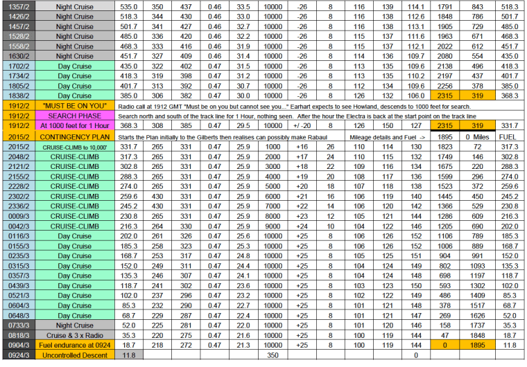
Reasons That Support this Hypothesis
For what are known, as pointers or reasons, chief among them is that the Electra did not make Howland Island at 1912 GMT so could not have “been on” the island or anywhere near it and any amount of searching is not going to find the island. Consider these points:
a. There was, obviously, no Astro available due to overcast. Three radio calls mentioned “Overcast” which by definition means cloud covering or obscuring the heavens… “Partly cloudy” by definition (in context, at the time), means some obstacle to achieving a clear view. The Electra failed to reach Howland. With Astro, Noonan would have been able to shoot Astro until the stars faded as dawn arrived and take the Electra in on Dead Reckoning to get it as close to Howland as possible.
b. There is definite uncertainty in the positioning of the Electra in the 200 to 100 miles (out) ranges given.
c. Earhart could not “get a minimum” on the letter “A’s” (morse code “A” keyed) sent by the USCG Itasca (although they were heard). This is a good indication that the signal Direction Finding (DF) equipment on board the Electra could not cope with the extended range and failed to allow a register of the “null.” On hearing the letter A’s, the DF Loop aerial is turned until the sound of the A’s fades away (the “null”), and a reading of the direction is taken in degrees off of the bezel at the base of the aerial. Say that the angle shows at 30 degrees to the right of the nose of the aircraft. In these early Direction Finders this can lead to an uncertainty with the possible “bearing” angle being ahead of the aircraft or behind the aircraft. If another bearing is taken off the signals a few minutes later and if the angle has increased to say 40 degrees, then the transmitting station is ahead of the aircraft as the aircraft has moved closer to the station. If the angle has decreased to 20 degrees, then the station is to the rear of the aircraft as the aircraft has moved further away from the station.
d. Simple mathematics would tell from the past history of the Groundspeed how far they had gone in 8.6 hours (especially in this hypothesis), because the speed is being regulated to the best L/D Smph.
e. Following the ETA would have seen them “on” Howland or lateral to Howland (probably to the south) at 2124 GMT in which case they would have seen Baker Island. This hypothesis favours a constant headwind, which on historical data had been 26 Smph at last count at the Ontario.
f. A continuing headwind is favoured in the hypothesis because of the July 2nd winds reported by USCG Itasca that noted a wind at 7000 feet of 31 Knots (36 Smph) from the east. This report was of this wind on the July 2nd, morning of their intended arrival at Howland.
g. This easterly flow of the wind across the Pacific in a wide band at the equator area is as shown in U.S. Navy weather charts for each month of the year which I have seen in the archives of the University of Texas and which were made early in WWII.
h. There were no remarks of “making 200 mph” made from Earhart, and the hypothesis believes that these were made as indications of distance only, one distance being “a correction.”
i. One point of the hypothesis is that the speed was regulated to the best L/D speed in the cruise, such that the normal acceleration “per hour ” increase in Groundspeed with a continuing power setting over several hours as weight is burned off, was repressed in order to give a best L/D speed to conserve fuel in case the attempt to reach Howland did fail. If a successful landing could be made in the Gilbert Islands without too much damage while being assisted by a friendly government, then that was a good option but not the best option. My MS Excel plot shows the continual saving of fuel by the lower power setting which could be used to give this economy.
j. High Frequency (HF) radio calls emitted by the Electra are claimed by some to show that signals heard at Strength 5 (S5), mean that the Electra was “on top of” or “very close to” the receiving station. This is nonsense. Radio gurus of all persuasions, for and against in different camps, say that you cannot tell distance on HF radio by S5 or any other S (volume) value… BUT in nearly all instances in the camps that say Earhart was close to Howland, this determination from radio gurus is ignored. I have worked next to a few radio technicians over the years and all have said, “You cannot tell the range of an HF Broadcasting Station by the strength or strength number applied. You may think that the aircraft is close but it could be a thousand miles away.” Earhart’s upper “Vee” HF aerial signal radiation may have been “reflected” off the atmosphere and allowed for a stronger reception. When she turned 90 degrees off the trackline to Howland and was “on the line 157-337,” the aerial radiated the transmission sideways towards Howland and not upwards …but my plot shows the Electra was still 320 miles from Howland at 1912 GMT and still roughly the same distance away at 2014 GMT at the time of her supposed “Last Transmission.”
Time Zone Charts for Select Periods AE Time Zones Charts 12 Jan 16
Next: The Contingency Plan…continued in Part 7…
Part 1 – The Beginning | Part 2 – PNG History/Topography | Part 3 – Wreckage is Found
Part 4 – Tangible Evidence | Part 5 – Analysis | Part 6 – Lae to Howland Island
Part 7 – Howland area to New Britain – To the Gilberts…
Part 8 – Howland area to New Britain – Flying Westwards for Rabaul
Part 9 – Not Seen, But Not Forgotten
Part 10 – 2017 Expedition Overview
References
HOME | Contact
COPYRIGHT 2004 – 2026
The contents of this website are Copyright to David Billings. No portion of this website story may be used without permission. All Rights to the content of this story based on the Earhart Lockheed Electra 10E aircraft being on New Britain Island are Copyright to David Billings and the story is the Intellectual Property of David Billings.
