
COPYRIGHT 2004 – 2026
The contents of this website are Copyright to David Billings. No portion of this website story may be used without permission. All Rights to the content of this story based on the Earhart Lockheed Electra 10E aircraft being on New Britain Island are Copyright to David Billings and the story is the Intellectual Property of David Billings.
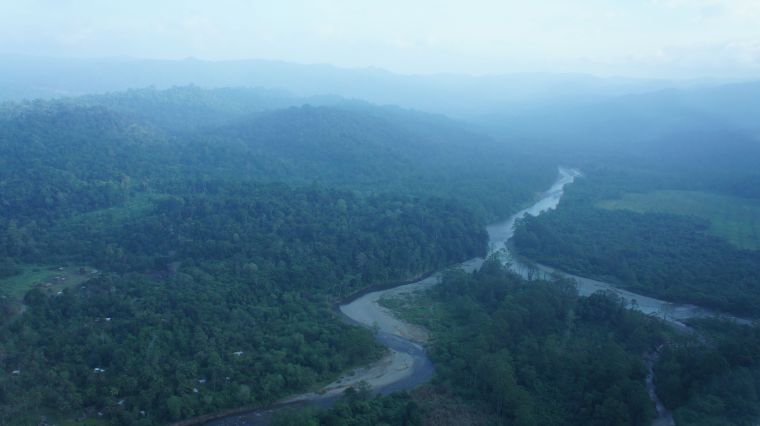
New Britain Island in the (then) Territory of New Guinea
History and Topography
New Britain Island is a large island northeast of the main island of New Guinea. The island is a former German colonial possession that was seized by Australia at the outbreak of the First World War. From then, until Papua New Guinea Independence in 1975, the Territory of New Guinea was administered by Australia. On the island of New Britain, there are two Provinces, East New Britain and West New Britain. We will focus on East New Britain, and the short history lesson will show the multifaceted link to the missing Electra.


The main centre of commerce of East New Britain was Rabaul until the town was devastated by volcanic eruptions in 1994, and the main centre of business is now Kokopo, 25 kilometres to the east of Rabaul. Rabaul was a tourist paradise with friendly people and wide tree-lined avenues. The panoramic views of the magnificent harbour were excellent prior to the 1994 eruption of Matupit Volcano, also known as Tavavur, which continues to cause alarm by smoking and blowing ash. Rabaul may never be rebuilt as the capital of the province as the threat of the cluster of nearby volcanoes is ever-present. Formerly, aircraft movements were at Lakunai close to Rabaul town and close to Matupit volcano, but now the airport for Rabaul is at Tokua at the northeast of the Gazelle Peninsula, 40 kilometres from Rabaul. Rabaul and Kokopo sit on the northern edge of the Gazelle Peninsula. To the south is a range of mountains across the peninsular called the Bainings Mountains with peaks to 7,000 feet elevation. Over half of the Gazelle Peninsula and the mountains are heavily wooded with thick jungle spread beneath a triple canopy.


The Second World War on New Britain
Japanese military forces invaded New Britain at Rabaul on the 23rd January 1942. There was a token force of Australian regular and militia troops at Rabaul and a flight of seven single-engined aircraft, technically called “fighters” but these CAC Wirraway aircraft were hopelessly inadequate against the superior Japanese aircraft used in the attack. Both the ground forces and the aircraft were destroyed, the surviving troops escaping on the northern and southern Gazelle Peninsula coasts. The Japanese had complete control over the land and air in New Britain from 1942, until American Army and Australian Army units covered by air power began the land counter-offensive starting out from the western landings in late 1943, and then fanning out along the north coast and along the south coast of New Britain in 1944. These units gradually moved eastwards and reached the narrow neck of land between the Gazelle Peninsula in the east and the main body of New Britain Island of which constitutes the larger part of the island. This narrow neck of land was reached in early 1945.
The Japanese had plenty of time to fortify Rabaul and the surrounding area, using captured prisoners of war to build three more airfields and dig 500 kilometres of tunnels in the hillsides. Over 700 anti-aircraft gun emplacements were constructed. Units of the USAAF, the RAAF, the USN and the RNZAF pounded Rabaul almost daily from late 1942 until mid-1945 dropping 20,000 tons of bombs on shipping and fortifications.
With the first landing on the west of the island at Arawe on the 15th December 1943 by the U.S. Army’s 112th Cavalry, the re-conquest of New Britain had begun. This landing was a diversionary tactic to draw Japanese forces away from Cape Gloucester at the extreme northwest of the island where the second landing by the U.S. 1st Marine Division took place on 23 December 1943. Both landings were supported by naval and airborne firepower. Subsequent to these successful landings and defeat of the Japanese forces against them; there then ensued a Japanese withdrawal across the island, the capture of Japanese airfields and a west-to-east movement with Japanese elements headed for the fortress of Rabaul in the extreme northeast of the island. The U.S. Forces were now chasing the Japanese stragglers and eliminating opposition. After reaching Cape Hoskins and almost completely destroying the original elements of the Japanese forces, the 1st Marine Division was replaced by the U.S. Army 40th Infantry Division.

Soon afterwards most of the American military units in New Guinea would be on the move to points west, in further tactical operations that isolated Japanese forces, the biggest of these being a major move from the area of Madang in New Guinea to Hollandia (now Jayapura) in what is now Indonesia.
Military tactics against the Japanese had now changed and the plan was an isolation campaign of Fortress Rabaul. General Douglas MacArthur was now to turn his attention to the Philippines and make good his famous promise. New Britain was turned over to the Australian Imperial Forces (AIF) to complete the re-taking of the western part of the island and bottle up the Japanese by creating a forward line across the island at the narrow neck of land below the Gazelle Peninsula on the eastern side. This land is a 38 kilometre-wide stretch of jungle between Open Bay in the north and Wide Bay in the south.
Therefore, from mid-1944 onwards the Australian Army would advance along the north and south coasts and hold a line across the island at the Gazelle Peninsula. Restricted in movement by air, sea and land, the Japanese had to sit out the persistent air raids on Rabaul and without re-supply by ships, they lived a subsistence lifestyle.
The Australian objective was to bottle-up the Japanese garrison in the Rabaul area that was thought to number around 38,000 troops but was actually nearly 100,000. The narrow neck of land separates the Gazelle Peninsula from the main part of New Britain Island and was ideal for this and a regimen of fighting patrols into the interior of the island at likely places of Japanese insertion was instituted by a battalion of infantry on the north coast and two battalions of infantry on the south coast. All of these battalions would eventually be engaged in repulsing Japanese probing attacks and interceptions of Japanese movements by establishing patrolling and ambush positions.
The Connection – An American Unit in support of the 5th Australian Infantry Division, 1st Australian Army, East New Britain
In order to provide mobility along the coast for the Australian Army in New Britain, the U.S. Army assigned Company “B” of the 594th Engineering Boat and Shore Regiment (EB&SR) equipped with Landing Craft Motorised (LCM’s); Landing Craft, Vehicle, Personnel (LCVP’s), a small number of J-Type patrol boats and a Picket boat. Company “B” had a main base Camp at Mal-Mal (Palmalmal) at the southeastern corner of Jacquinot Bay. Company “B” of the 594th, and their initial fleet of 32 LCM’s and LCVP’s and 3 J-Boats, now came under the command of the Australian 5th Division of 1st Australian Army, which had headquarters at Wunung Plantation, Jacquinot Bay, some 70 nautical miles by sea from the fighting zone in the Waitavalo River area near Tol Plantation. Company “B” moved Australian Army units up the coast for the attack on the Japanese at Wide Bay. They set up a regular resupply run from Jacquinot Bay in support of these troops in the final moves to Tol Plantation and Kalai Plantation at Wide Bay, a sea journey which would take up to 10 hours by LCM. Company “B” of the 594th EB&SR was an essential element of the New Britain campaign.

On 10 April 1945, the 11th Australian Infantry Battalion replaced another battalion in the Kalai/Tol area. The 11th Battalion was transported by the 594th EB&SR to their designated deployment locations: Headquarters Company and “A”, “B” and C” Companies were positioned at the Tol Plantation area, and “D” Company was to be located at Kalai Plantation in the south of Wide Bay. “D” Company was allotted the area to the south of the Mevelo River as their patrolling area and the other three companies at Tol Plantation were to patrol the area north of the Mevelo River.
Part 1 – The Beginning | Part 2 – PNG History/Topography | Part 3 – Wreckage is Found
Part 4 – Tangible Evidence | Part 5 – Analysis | Part 6 – Lae to Howland Island
Part 7 – Howland area to New Britain – To the Gilberts…
Part 8 – Howland area to New Britain – Flying Westwards for Rabaul
Part 9 – Not Seen, But Not Forgotten
Part 10 – 2017 Expedition Overview
References
HOME | Contact
COPYRIGHT 2004 – 2026
The contents of this website are Copyright to David Billings. No portion of this website story may be used without permission. All Rights to the content of this story based on the Earhart Lockheed Electra 10E aircraft being on New Britain Island are Copyright to David Billings and the story is the Intellectual Property of David Billings.
